 OSU Pytheas - Data Catalog
MIO UMR 7294 CNRS
Type of resources
Available actions
Topics
INSPIRE themes
Keywords
Contact for the resource
Provided by
Formats
Representation types
Update frequencies
status
Scale
-
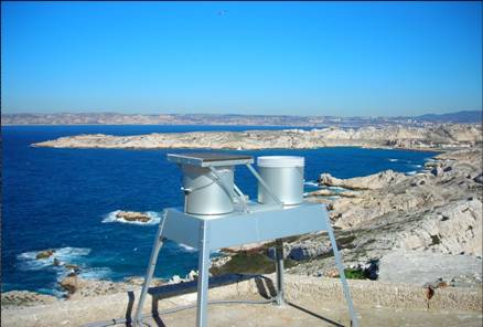
OBJECTIF – Mesures des flux de matières d’origine atmosphérique en mer Méditerranée dans le cadre du réseau MOOSE Mesures en réseau avec cap Béar et cap ferrat Le milieu marin est de plus en plus soumis à l’influence anthropique, très directement sur la frange littorale, mais également au large par les retombées atmosphériques qui peuvent se propager très loin. La Méditerranée étant une mer oligotrophe, c’est-à-dire pauvre en élément nutritifs, tout apport d’éléments peut être un facteur de développement biologique significatif. Par contre l’apport de contaminants et de polluants par voie atmosphérique peut être un facteur perturbant ou inhibant l’écosystème. Le site du Frioul offrant l’opportunité de quantité les retombées atmosphériques dans la zone côtière, le Service d’Observation du MIO a proposé d’utiliser ce site pour installer des collecteurs de retombées atmosphériques. Collecteur de retombées atmosphériques sèches et pluies (MTX Italia) installé sur une plateforme dans l’enceinte du sémaphore de Pomègues Un collecteur de type MTX permet de récupérer les retombées sèches et les retombées humides (pluies) séparément. Parallèlement, un système de pompage en continu des aérosols a été mise en place dans la pièce supérieure du sémaphore. Il est composé de pompes à vide reliées à un compteur qui aspire en continu l’air qui est filtré sur un filtre disposé à l’extérieur. La collecte des échantillons est assurée chaque semaine par un opérateur du MIO. Par ailleurs le MIO assure le traitement et l’analyse de la matière récoltée. Les éléments suivants, source de fertilisation du milieu marin sont déterminés : - Azote total - Phosphore total - Carbone total - Formes solubles de l’azote (nitrate, nitrite, ammonium) - Formes solubles du phosphore (orthophosphates) - Formes particulaires de l’azote, du phosphore et du carbone. SITE : Iles de Pomègues - Sémaphore du Frioul PROGRAMME DE RATTACHEMENT - Mediterranean Oceanic Observing System on Environment : MOOSE - Labellisation : SOERE - INSU - Financement : SOERE – INSU – Ville de Marseille RESPONSABLE LOCAL: - Patrick Raimbault DISPONIBLITE DES DONNEES : - Base de données SEDOO: http://mistrals.sedoo.fr/MOOSE/ PARTICIPANTS : - M. Fornier : collecte - V. Lagadec analyses chimiques - P. Raimbault : analyses élémentaires PARTENAIRES - MOOSE - CHARMEX- Ville de Marseille – Parc des îles du Frioul - OSU de Villefranche et de Banyuls
-
Le projet interdisciplinaire UECOCOT vise à développer des outils d'aide à la gestion durable des activités minières afin de permettre la meilleure cohabitation possible entre dynamique naturelle des environnements (et leur capacité de résistance aux dommages et de résilience) et les activités humaines (industrielles ou non). L'objectif global du projet est de répondre à la question " comment adapter , à un coût socio-économique acceptable, les activités minières pour que leur impact reste compatible avec la durabilité des écosystèmes côtiers et littoraux". Pour atteindre un tel objectif, le projet UECOCOT repose sur une approche multi-sites ayant des impacts miniers différents. Dans le Pacifique sud, le site choisi est le lagon de Koné (Nouvelle-Calédonie) à proximité duquel s'est implanté une mine de nickel et touché par des apports de particules riches en éléments métalliques (Ni, Cr, Co, Mn) issues de l'altération des massifs miniers latéritiques développés sur des péridotites. C'est dans ce cadre qu'a eu lieu en février 2018 une campagnes océanographique multidisciplinaire dans le lagon de Koné dont l'objectif était d'acquérir des informations sur : i) les flux hydrodynamiques et biogéochimiques entre la côte, le lagon et l'océan et les connectivités au sein même du lagon, ii) l'état écologique du lagon et son fonctionnement End to End (hydro-bio-géochimique) , iii) les apports miniers directs ou indirects (avec un focus sur les métaux) et leur impact sur le fonctionnement biogéochimique. L'ensemble des résultats acquis doit permettre de valider un modèle numérique de biologie intégrant les aspects physiologiques et comportementaux des organismes (plancton et benthos) liés à la contamination du milieu et à la circulation hydrodynamique au sein du lagon. Il doit en particulier aboutir à une meilleure compréhension du rôle de la barrière récifale sur la régulation hydrodynamique et ainsi permettre d'affiner les prévisions en terme de contamination du lagon suite à une modification de la structure récifale sous l'effet conjugué de contraintes anthropiques et climatiques. Ce projet s'inscrit dans le réseau international AMEDEE (Activité Minière, Environnement, Développement Economique, Ethiques) qui regroupe les programmes de R&D de 40 institutions scientifiques (Colin, 2016)
-
JULIO (Judicious Location for Intrusions Observations) mooring is located close to the 100 m-deep isobath (around 5.25°E and 43.13°N), offshore Marseille. With its bottom-moored (300kHz) ADCP, it enables measuring horizontal currents (every 4 m and every ½ h) through the water column, and among others, identifying periods of exchange between the Northern Current and the continental shelf. It is one crucial component in the study of the coastal-offshore gradient from Marseille to the MOOSE 42°N5°E station, and potential covariances with the MIO radar and other MIO or international observing systems, as well as with the SOMLIT site (including also an ADCP) in the bay of Marseille. Moreover, with a bottom CTD, it can detect environmental anomalies in classical hydrographic data, useful for oceanographers. As one of the rare station at the interface between the continental shelf and offshore, it will allow to observe the long-term evolution of the Northern Current in the context of climate change and anthropogenic pressure, and its potential varying impact on the Gulf of Lion. The data are of course also crucial for modellers. Moreover they show a great potential when supplementing other MOOSE data (glider and radar). Timeseries : - JULIO 1 - 12/02/2012 -> 23/10/2012, every 4 minutes ; - JULIO 2 - 26/09/2013 -> 28/03/2014, every 4 minutes ; - JULIO 3 - 17/07/2014 -> 10/04/2015, every 4 minutes ; - JULIO 4 - 07/12/2020 -> 21/08/2021, every 5 minutes ; - JULIO 5 - 01/09/2021 -> 23/06/2022, every 4 minutes ; JULIO (Judicious Location for Intrusions Observations) est situé à proximité de l'isobathe de 100 m de profondeur (environ 5,25°E et 43,13°N), au large de Marseille. Grâce à son ADCP (300 kHz), il permet de mesurer les courants horizontaux (tous les 4 m et toutes les ½ h) à travers la colonne d'eau et, entre autres, d'identifier les périodes d'échange entre le courant du Nord et le plateau continental. Il s'agit d'un élément crucial dans l'étude du gradient littoral-offshore de Marseille à la station MOOSE 42°N5°E, et des covariances potentielles avec le radar MIO et autres systèmes d'observation MIO ou internationaux, ainsi qu'avec le site SOMLIT (incluant également un ADCP) dans la baie de Marseille. De plus, avec un CTD de fond, il peut détecter les anomalies environnementales dans les données hydrographiques classiques, utiles aux océanographes. En tant qu'une des rares stations à l'interface entre le plateau continental et le large, elle permettra d'observer l'évolution à long terme du courant du Nord dans le contexte du changement climatique et de la pression anthropique, et son impact potentiel variable sur le Golfe du Lion. Les données sont bien sûr également cruciales pour les modélisateurs. De plus, ils présentent un grand potentiel en complément d'autres données MOOSE (planeur et radar). Série temporelle #1: - JULIO 1 - 12/02/2012 -> 23/10/2012, toutes les 4 minutes ; - JULIO 2 - 26/09/2013 -> 28/03/2014, toutes les 4 minutes ; - JULIO 3 - 17/07/2014 -> 10/04/2015, toutes les 4 minutes ; - JULIO 4 - 07/12/2020 -> 21/08/2021, toutes les 5 minutes ; - JULIO 5 - 01/09/2021 -> 23/06/2022, toutes les 4 minutes ;
-
JULIO (Judicious Location for Intrusions Observations) mooring is located close to the 100 m-deep isobath (around 5.25°E and 43.13°N), offshore Marseille. With its bottom-moored (300kHz) ADCP, it enables measuring horizontal currents (every 4 m and every ½ h) through the water column, and among others, identifying periods of exchange between the Northern Current and the continental shelf. It is one crucial component in the study of the coastal-offshore gradient from Marseille to the MOOSE 42°N5°E station, and potential covariances with the MIO radar and other MIO or international observing systems, as well as with the SOMLIT site (including also an ADCP) in the bay of Marseille. Moreover, with a bottom CTD, it can detect environmental anomalies in classical hydrographic data, useful for oceanographers. As one of the rare station at the interface between the continental shelf and offshore, it will allow to observe the long-term evolution of the Northern Current in the context of climate change and anthropogenic pressure, and its potential varying impact on the Gulf of Lion. The data are of course also crucial for modellers. Moreover they show a great potential when supplementing other MOOSE data (glider and radar). Timeserie #6 : - JULIO 6 - 24/06/2022 to 22/06/2023; JULIO (Judicious Location for Intrusions Observations) est situé à proximité de l'isobathe de 100 m de profondeur (environ 5,25°E et 43,13°N), au large de Marseille. Grâce à son ADCP (300 kHz), il permet de mesurer les courants horizontaux (tous les 4 m et toutes les ½ h) à travers la colonne d'eau et, entre autres, d'identifier les périodes d'échange entre le courant du Nord et le plateau continental. Il s'agit d'un élément crucial dans l'étude du gradient littoral-offshore de Marseille à la station MOOSE 42°N5°E, et des covariances potentielles avec le radar MIO et autres systèmes d'observation MIO ou internationaux, ainsi qu'avec le site SOMLIT (incluant également un ADCP) dans la baie de Marseille. De plus, avec un CTD de fond, il peut détecter les anomalies environnementales dans les données hydrographiques classiques, utiles aux océanographes. En tant qu'une des rares stations à l'interface entre le plateau continental et le large, elle permettra d'observer l'évolution à long terme du courant du Nord dans le contexte du changement climatique et de la pression anthropique, et son impact potentiel variable sur le Golfe du Lion. Les données sont bien sûr également cruciales pour les modélisateurs. De plus, ils présentent un grand potentiel en complément d'autres données MOOSE (planeur et radar). Série temporelle #6 : - JULIO 6 - 24/06/2022 to 22/06/2023;
-
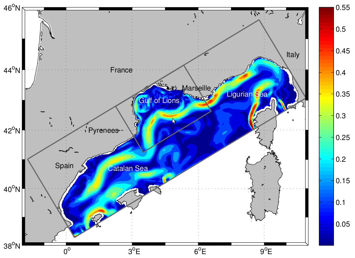
The LAgrangian Transport EXperiment (LATEX) project (2008-2011) is designed to study the mechanisms of formation of anticyclonic eddies and their influence on cross-shelf exchanges in the western part of the GoL. The dynamics of mesoscale eddies is particularly important in this part of the GoL since it represents a key region for regulating the outflow from the continental shelf. The eddy dynamics is investigated using Symphonie, a 3-dimensional, primitive equation model, with a free sea surface, hybrid sigma coordinates, based on Boussinesq and hydrostatic approximations [Marsaleix et al., 2006, 2008]. We use the upwind-type advection-diffusion scheme adapted by Hu et al. [2009] to improve the ability of the model to reproduce coastal mesoscale eddies in the western part of the GoL. In the present study, the model is implemented over the whole GoL with an horizontal resolution of 1 km × 1 km (Figure 1). The vertical discretization consists of 40-hybrid vertical levels. The vertical resolution varies from 1 m in the upper ocean to 40 m near the bottom. "For a complete review of the LATEX projet, see : - Petrenko, A., A., Doglioli, A.M., Nencioli, F., Kersalé, M., Hu, Z., d'Ovidio, F. (2017). A review of the LATEX project: mesoscale to submesoscale processes in a coastal environment. Ocean Dynam., 67:513 - doi: 10.1007/s10236-017-1040-9 - https://doi.org/10.1007/s10236-017-1040-9 ----- Le projet LAgrangian Transport EXperiment (LATEX) (2008-2011) est conçu pour étudier les mécanismes de formation des tourbillons anticycloniques et leur influence sur les échanges entre plateaux dans la partie occidentale du GdL. La dynamique des tourbillons à méso-échelle est particulièrement importante dans cette partie du GdL, car elle représente une région clé pour la régulation du flux sortant du plateau continental. La dynamique des tourbillons est étudiée à l'aide de Symphonie, un modèle d'équation primitive tridimensionnel, avec une surface de mer libre, des coordonnées sigma hybrides, basé sur Boussinesq et des approximations hydrostatiques [Marsaleix et al., 2006, 2008]. Nous utilisons le schéma d'advection-diffusion de type vent debout adapté par Hu et al [2009] pour améliorer la capacité du modèle à reproduire les tourbillons côtiers à méso-échelle dans la partie occidentale du GdL. Dans la présente étude, le modèle est mis en œuvre sur l'ensemble du GdL avec une résolution horizontale de 1 km × 1 km (Figure 1). La discrétisation verticale est constituée de 40 niveaux verticaux hybrides. La résolution verticale varie de 1 m dans la partie supérieure de l'océan à 40 m près du fond. Pour plus d'information sur le projet LATEX : - Petrenko, A., A., Doglioli, A.M., Nencioli, F., Kersalé, M., Hu, Z., d'Ovidio, F. (2017). A review of the LATEX project: mesoscale to submesoscale processes in a coastal environment. Ocean Dynam., 67:513 - doi:10.1007/s10236-017-1040-9 - https://doi.org/10.1007/s10236-017-1040-9
-
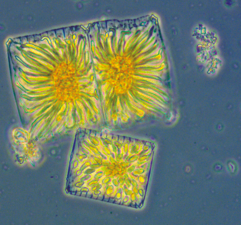
The New Caledonia lagoons show high seasonal and interannual variability (related to El Niño – Southern oscillation – ENSO - variability). They present a great diversity of local situations linked to differences in their geomorphology, to the nature of terrigenous inputs and to varied anthropogenic pressure. This variability impacts the structure of planktonic communities and their biodiversity. The scientific objectives of the CLAPPP project developed on 6 New Caledonia lagoons are : - 1) to describe the local environmental conditions and their seasonality, - 2) to understand the heterogeneity of phytoplankton communities at the biological, spatial and/or temporal levels, - 3) to study the role of this diversity in the functioning of coral ecosystems and the regulation of biogeochemical cycles, and - 4) to assess the importance of phytoplankton as an index of productivity and health of the lagoons in relation with local stress conditions and the risk of HABs. DOI: - https://doi.org/10.34930/2b52defe-e5f3-4fe2-9f2f-741d90e624ea Citation: Rodier, M., & Arfi, R. (2020). CLAPPP - New Caledonian lagoons: Physics and Phytoplankton processes [Data set]. MIO UMR 7294 CNRS. https://doi.org/10.34930/2B52DEFE-E5F3-4FE2-9F2F-741D90E624EA
-

This Application is a simple calculator that estimates Turbulent Air-Sea Fluxes based on input variables such as wind speed, air temperature, or relative humidity. The input variables can be easily set by hand with sliders. The present Air-Sea Flux Calculator application makes it easy to get an estimate of the fluxes at Sea of for Educational purposes The code is a simplification of the well known bulk algorithm so-called COARE 3.0 (Fairall et al. 2003). The authors of this code are Nicolas Bourras and Denis Bourras (MIO CNRS UMR 7294, Institut Méditerranéen d'Océanologie, Institut Pytheas CNRS UAR 3470, Aix-Marseille University). Citation: Bourras, N., & Bourras, D., (2023). Air-Sea flux calculator [Application].
-
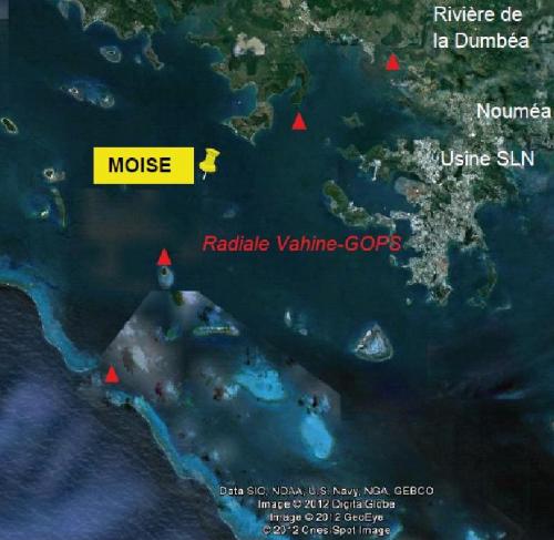
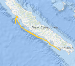
The MOISE project is part of a medium- and long-term approach to monitoring the coastal environment in New Caledonia. Initiated at the end of 2011, this monitoring is based on the installation of a fixed mooring with automatic physico-chemical, optical and biological measurement systems. This approach makes it possible to address the different scales of temporal variability characteristic of the dynamics and functioning of the lagoon ecosystem, including the daily scale. Since 2012, this high-frequency in situ monitoring has been supplemented by monthly monitoring with discrete measurements and vertical profiles over the entire water column; the parameters measured and the methods used are modelled on those of the SOMLIT network, with a view to MOISE's accreditation as an observation station. Medium and long term observation of the coastal environment in New Caledonia. Climatic variability in tropical zones. Evolution of the monthly, seasonal and interannual variability of the hydrological and biogeochemical characteristics of marine waters at a point located off the Bay of Dumbéa (N-NW of Noumea, New Caledonia) on a depth of 10m. Measurement of the impact of natural and anthropogenic forcings on the environment, study/quantification of the consequences of this variability, both natural and anthropogenic, on the structuring and functioning of the pelagic ecosystem, and in particular on the appearance of diazotrophic blooms. Validation of the images obtained by different ocean color sensors by monitoring the variations of the "water color" for an adjustment of the algorithms of calculation of the chlorophyll obtained from satellite reflectance. Possible measurements of the impact of the atmospheric plume of the SLN (Société Le Nickel = nickel treatment by pyrometallurgy) following preliminary work.
-

What drives phytoplankton diversity at fine scales? Phytoplankton diversity is a key component in ocean biogeochemical services and contributes to the resilience and health of ocean ecosystems in respect to local and global stressors, including climate change. Understanding the mechanisms behind phytoplankton diversity in the open ocean is a matter of concern, especially in these years in which large Marine Protected Areas are created in international waters and an international legally binding treaty on Marine Biodiversity Beyond National Jurisdiction is under negotiation. Model studies suggest that finescale ocean dynamics are an important driver of plankton diversity and several scenarios have been suggested. In situ observations however are difficult to perform, due to the ephemeral nature of finescale features and the difficulty of tracking them from available remote sensing. This observational limit will be largely reduced by the SWOT mission, in particular during the fast sampling phase, opening new possibilities to biophysical experiments in the open ocean. The BIOSWOT-Med campaign aims at exploiting SWOT observations for unveiling the drivers of phytoplankton diversity in the Western Mediterranean. The western Mediterranean Sea is characterized by high plankton diversity, low nutrient concentration, and weak oceanic circulation. Here, finescale features, even if weak and short-lived, can strongly modulate the microbial community structure. To study the finescale biophysical coupling, and its impact of phytoplankton diversity, the BIOSWOT-Med campaign will follow the temporal evolution of eddies and filaments over the western Mediterranean SWOT crossover. The physical-biochemical coupling at the frontal zone between Atlantic Water recently entered in the Mediterranean basin and modified Atlantic Water coming from cyclonic circulation in the western Mediterranean basin will be studied through an adaptive Lagrangian sampling strategy using the software SPASSO (Software Package for an Adaptive Satellite-based Sampling for Oceanographic cruises) developed in previous research cruises. This physical information will be paired by a multi-sensor characterization of the planktonic community, including advanced molecular (meta-transcriptomics, metagenomics and meta-barcoding) techniques, and the use of autonomous and robotic platforms. Institutes involved in the campaign: AMU, LOCEAN, CEA, CNR, CNRS, CSIC, Fisheries and Ocean Canada, IFREMER, IRD, MBARI, NWRA, OGS, SHOM, Sorbonne Université, SZN, UCSD, ULCO, University of Exeter, University of Washington.
-
JULIO (Judicious Location for Intrusions Observations) mooring is located close to the 100 m-deep isobath (around 5.25°E and 43.13°N), offshore Marseille. With its bottom-moored (300kHz) ADCP, it enables measuring horizontal currents (every 4 m and every ½ h) through the water column, and among others, identifying periods of exchange between the Northern Current and the continental shelf. It is one crucial component in the study of the coastal-offshore gradient from Marseille to the MOOSE 42°N5°E station, and potential covariances with the MIO radar and other MIO or international observing systems, as well as with the SOMLIT site (including also an ADCP) in the bay of Marseille. Moreover, with a bottom CTD, it can detect environmental anomalies in classical hydrographic data, useful for oceanographers. As one of the rare station at the interface between the continental shelf and offshore, it will allow to observe the long-term evolution of the Northern Current in the context of climate change and anthropogenic pressure, and its potential varying impact on the Gulf of Lion. The data are of course also crucial for modellers. Moreover they show a great potential when supplementing other MOOSE data (glider and radar). Timeserie #3 : - JULIO 3 - 17/07/2014 to 10/04/2015; JULIO (Judicious Location for Intrusions Observations) est situé à proximité de l'isobathe de 100 m de profondeur (environ 5,25°E et 43,13°N), au large de Marseille. Grâce à son ADCP (300 kHz), il permet de mesurer les courants horizontaux (tous les 4 m et toutes les ½ h) à travers la colonne d'eau et, entre autres, d'identifier les périodes d'échange entre le courant du Nord et le plateau continental. Il s'agit d'un élément crucial dans l'étude du gradient littoral-offshore de Marseille à la station MOOSE 42°N5°E, et des covariances potentielles avec le radar MIO et autres systèmes d'observation MIO ou internationaux, ainsi qu'avec le site SOMLIT (incluant également un ADCP) dans la baie de Marseille. De plus, avec un CTD de fond, il peut détecter les anomalies environnementales dans les données hydrographiques classiques, utiles aux océanographes. En tant qu'une des rares stations à l'interface entre le plateau continental et le large, elle permettra d'observer l'évolution à long terme du courant du Nord dans le contexte du changement climatique et de la pression anthropique, et son impact potentiel variable sur le Golfe du Lion. Les données sont bien sûr également cruciales pour les modélisateurs. De plus, ils présentent un grand potentiel en complément d'autres données MOOSE (planeur et radar). Série temporelle #3 : - JULIO 3 - 17/07/2014 to 10/04/2015;