Mediterranean Sea, Western Basin
Type of resources
Topics
INSPIRE themes
Keywords
Contact for the resource
Provided by
Formats
Representation types
Update frequencies
status
Scale
-
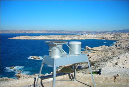
OBJECTIF – Mesures des flux de matières d’origine atmosphérique en mer Méditerranée dans le cadre du réseau MOOSE Mesures en réseau avec cap Béar et cap ferrat Le milieu marin est de plus en plus soumis à l’influence anthropique, très directement sur la frange littorale, mais également au large par les retombées atmosphériques qui peuvent se propager très loin. La Méditerranée étant une mer oligotrophe, c’est-à-dire pauvre en élément nutritifs, tout apport d’éléments peut être un facteur de développement biologique significatif. Par contre l’apport de contaminants et de polluants par voie atmosphérique peut être un facteur perturbant ou inhibant l’écosystème. Le site du Frioul offrant l’opportunité de quantité les retombées atmosphériques dans la zone côtière, le Service d’Observation du MIO a proposé d’utiliser ce site pour installer des collecteurs de retombées atmosphériques. Collecteur de retombées atmosphériques sèches et pluies (MTX Italia) installé sur une plateforme dans l’enceinte du sémaphore de Pomègues Un collecteur de type MTX permet de récupérer les retombées sèches et les retombées humides (pluies) séparément. Parallèlement, un système de pompage en continu des aérosols a été mise en place dans la pièce supérieure du sémaphore. Il est composé de pompes à vide reliées à un compteur qui aspire en continu l’air qui est filtré sur un filtre disposé à l’extérieur. La collecte des échantillons est assurée chaque semaine par un opérateur du MIO. Par ailleurs le MIO assure le traitement et l’analyse de la matière récoltée. Les éléments suivants, source de fertilisation du milieu marin sont déterminés : - Azote total - Phosphore total - Carbone total - Formes solubles de l’azote (nitrate, nitrite, ammonium) - Formes solubles du phosphore (orthophosphates) - Formes particulaires de l’azote, du phosphore et du carbone. SITE : Iles de Pomègues - Sémaphore du Frioul PROGRAMME DE RATTACHEMENT - Mediterranean Oceanic Observing System on Environment : MOOSE - Labellisation : SOERE - INSU - Financement : SOERE – INSU – Ville de Marseille RESPONSABLE LOCAL: - Patrick Raimbault DISPONIBLITE DES DONNEES : - Base de données SEDOO: http://mistrals.sedoo.fr/MOOSE/ PARTICIPANTS : - M. Fornier : collecte - V. Lagadec analyses chimiques - P. Raimbault : analyses élémentaires PARTENAIRES - MOOSE - CHARMEX- Ville de Marseille – Parc des îles du Frioul - OSU de Villefranche et de Banyuls
-

Le projet CHROME « Continuous High Resolution Observation of the MEditerranean sea », a été financé par la fondation A*MIDEX, a permis d'étudier le contexte physico-chimique et biogéochimique des eaux de surface en intégrant des échelles spatio-temporelles de haute résolution (méso-échelle et hebdomadaire). Ces échelles d’observation de l’écosystème marin sont indispensables pour comprendre et intégrer au mieux le rôle des structures physiques à méso-échelle et des évènements météorologiques ponctuels tout en englobant la variabilité saisonnière classique. Pour cela, un système de mesures automatisées à haute résolution a été mis en place à bord d’un navire d’opportunité, le C/F Carthage de la Compagnie Tunisienne de Navigation (CTN), à savoir: la FerryBox et le Cytomètre en Flux de type CytoSense. Ce navire traverse la Méditerranée quatre fois par semaine, de Tunis à Marseille et de Tunis à Gênes. CHROME s'est appuyé sur un consortium international composé par l'Institut Méditerranéen d'Océanologie (MIO), l’Institut National des Technologies et des Sciences de la Mer (INSTM), le Laboratoire d’Océanologie et de Géosciences (LOG), la Station Biologique de Roscoff (SBR), le Laboratoire d'Océanographie de Villefranche-sur-Mer (LOV), l’Institut National de Géophysique et de Volcanologie (INGV) et l’Institut de Mathématique de Luminy (I2M). The CHROME project (Continuous High Resolution Observation of the MEditerranean sea) is financially supported by the A*MIDEX Foundation. Its objective was to study the physicochemical and biogeochemical context of the surface waters, integrating high-resolution space and time scales (mesoscale and weekly). Observing the marine environment at this scale is important to understand and integrate as well as possible the roles of mesoscale physical structures and single meteorological events (pulse events) while at the same time encompassing conventional seasonal variability. With this in mind, a high-resolution automated measuring system was set up using the Tunisian ship of opportunity C/F Carthage of the Compagnie Tunisienne de Navigation (CTN) equipped with modern and validated technological appliances, i.e. a FerryBox and a CytoSense flow cytometer. This ship crosses the Mediterranean sea four times a week between Tunis and Marseille and between Tunis and Genoa. CHROME was supported by an international consortium associating the Mediterranean Institute of Oceanography (MIO), the National Institute of Marine Sciences and Technologies (INSTM), the Oceanology and Geoscience Laboratory (LOG), the Roscoff Biological Station (SBR), the Luminy Institute of Mathematics (I2M), the Oceanology Laboratory of Villefranche-sur-Mer (LOV) and the National Institute of Geophysics and Vulcanology (INGV).
-
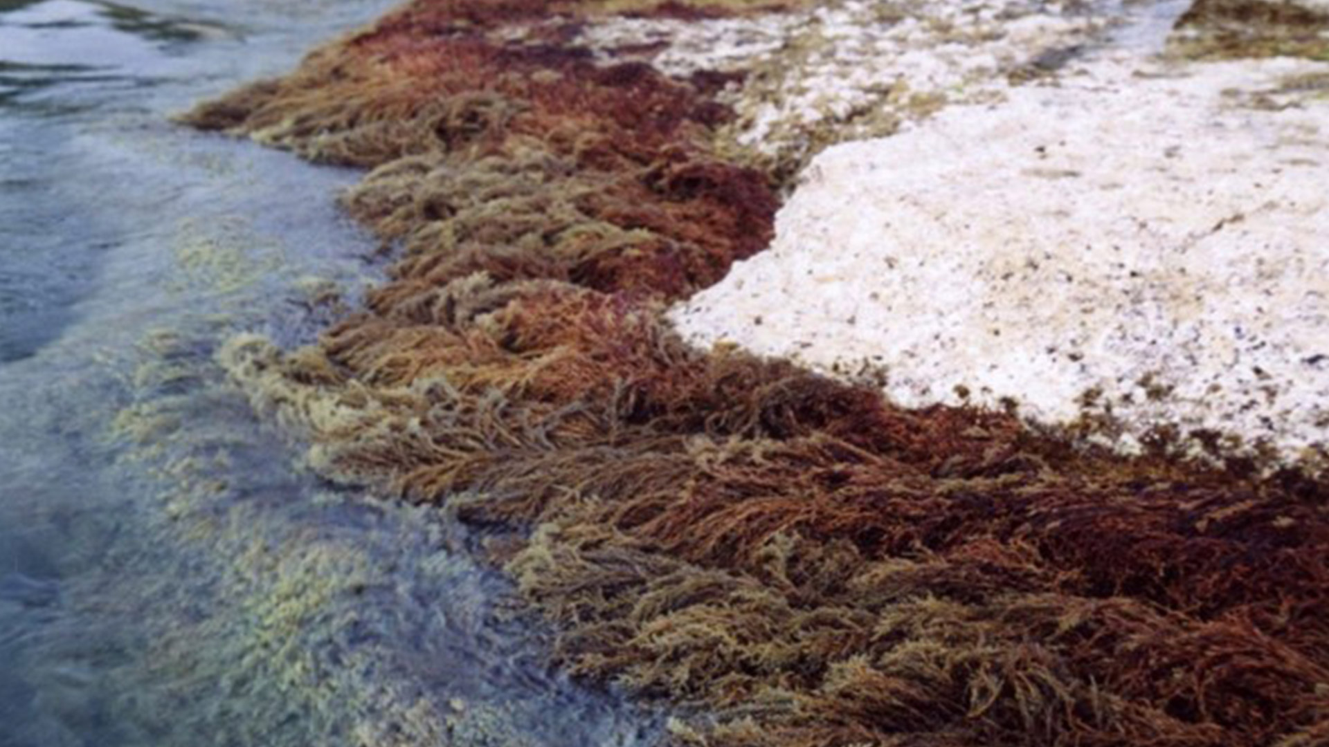
CARLIT : Évaluation de l’état écologique du littoral rocheux méditerranéen français – Descripteur ‘Macroalgue’ de la Directive Européenne Cadre sur l’Eau Dans le cadre du contrôle de surveillance DCE-Bassin Rhône côtier Méditerranée, la mise en œuvre du descripteur ‘Macroalgue’ a été mise en place depuis le printemps 2007 en utilisant la méthode CARLIT. Les communautés rocheuses des étages médio- et infralittoraux (frange supérieur de l’étage infralittoral souvent émergée), la géomorphologie et la nature de la roche ont été cartographiées à l’échelle 1/2 500ème. Un niveau de sensibilité écologique face aux perturbations sur une échelle de 1 (peu sensible) à 20 (très sensible) est attribué à chaque communauté. Les communautés ayant les niveaux de sensibilité les plus forts représentent les communautés climax de la zone littorale. Par une analyse géo-référencée, un indice de qualité environnementale est calculé, et permet ainsi de déterminer, pour chaque masse d’eau, un statut écologique établi suivant les critères de la Directive Cadre Européenne sur l’Eau. Les littoraux sédimentaires sont ignorés à l’exception des baies naturelles très fermées où les phanérogames peuvent être abondantes, ainsi que l’intérieur des ports et des marinas. Ces deux dernières zones étant trop perturbées, elles nécessitent l’utilisation d’autres indices comme par exemple l’analyse de l’eau. L’intégralité des côtes rocheuses françaises méditerranéennes a été cartographie (depuis 2007). La méthode CARLIT (CARtographie LITtorale) développée par Ballesteros et al., 2007 et modifié par Blanfuné et al., 2017, consiste à mesurer l'abondance et la distribution des communautés ou espèces de macroalgues dominantes présentes sur les substrats rocheux de l’étage médiolittoral et de l'horizon supérieur de l’étage infralittoral (0-50 cm de profondeur) en fonction de la géomorphologie de la côte (présence de falaise supérieure à 15 m de hauteur) et de la nature du substrat (naturel, artificiel, etc.). L'abondance des communautés est cartographiée à partir d’une petite embarcation longeant la côte au plus près du littoral et à 4-5 km/h. La méthode ne s’applique donc pas à des masses d’eau dont la côte est sableuse, où le descripteur macroalgues n’est pas pertinent. Par une analyse géoréférencée, un indice de qualité environnementale (EQR) est calculé, et permet ainsi de déterminer, pour chaque masse d’eau, un statut écologique (ES) établi suivant les critères de la Directive Cadre Européenne sur l’Eau. Une deuxième vague d’évaluation a commencé depuis 2012.
-
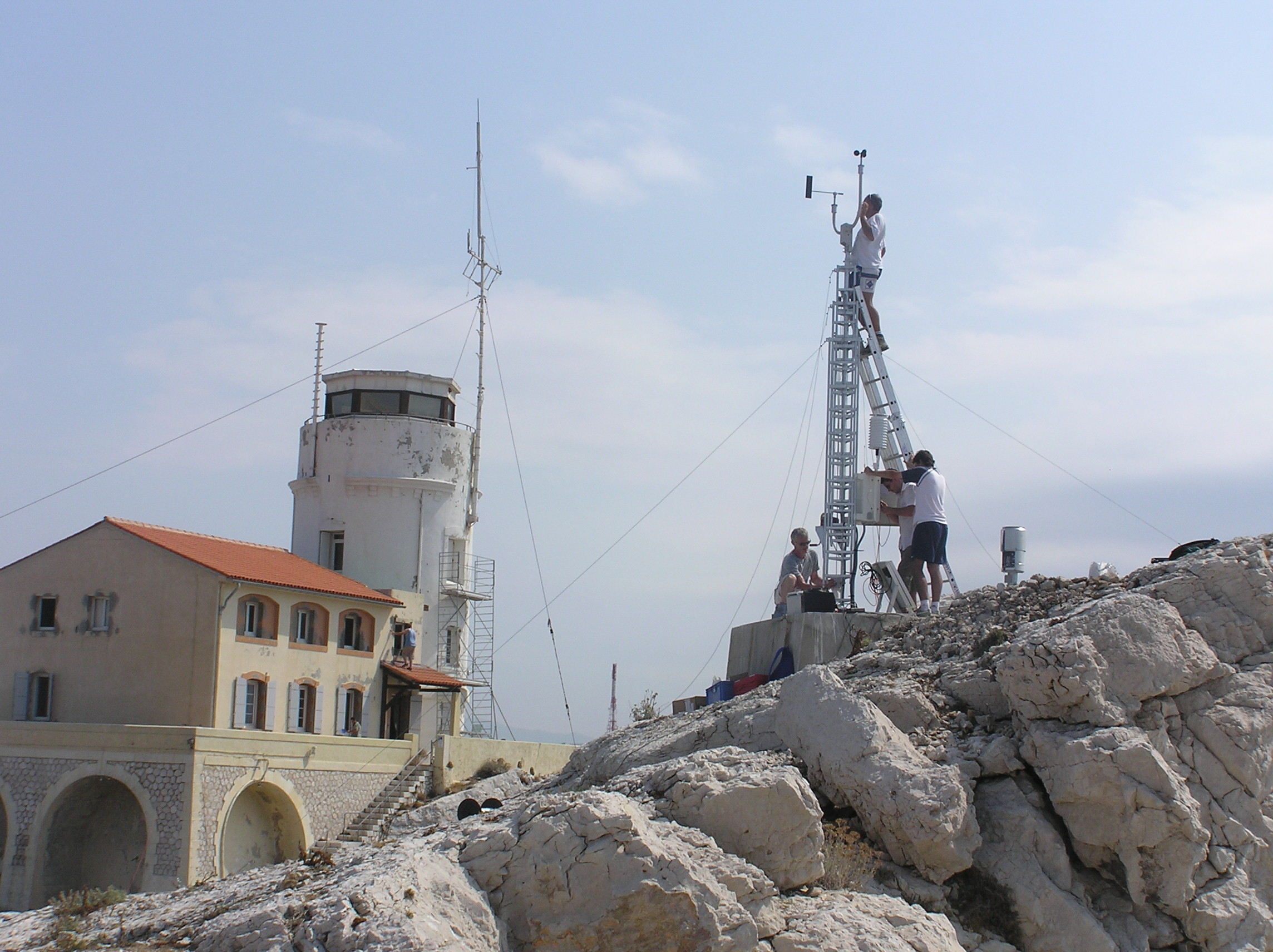
Meteorological data from the Bay of Marseille based on the measurements taken on the site located on the Pomegues island SITE : Iles de Pomègues – Sémaphore du Frioul - Latitude 43°15’59 N - Longitude 5°17’39 W - Hauteur : 25 m PROGRAMME DE RATTACHEMENT : - Mediterranean Oceanic Observing System on Environment : MOOSE - SOMLIT - Labellisation : SOERE - INSU - Financement : SOERE – INSU Read the abstract and supplemental information provided in the Vector template for more details. EQUIPEMENTS: - Station météorologique Auria avec transmission temps réel - Anémomètre et girouette - Baromètre - Pyranomètre - pluviomètre PARAMETRES MESURES : - Vent ( vitesse et direction) - Température et pression atmosphérique - Irradiance - Pluie DISPONIBLITE DES DONNEES : - Visualisation temps réel - Base de données du Service d'Observation du MIO RESPONSABLE : P. Raimbault (2019) D. Bourras (2024) PARTICIPANTS : - M. Fornier (Tech Univ) et M. Lafont (Tech Univ) : maintenance - Denis Bourras, Maurice Libes PARTENAIRES : - MOOSE - SOMLIT – MERMEX – CHARMEX -Ville de Marseille - Parc des îles du Frioul -CITATION : Raimbault, P., & Yohia, C. (2017). Météorologie locale en baie de Marseille : Frioul [Data set]. MIO UMR 7294 CNRS. https://doi.org/10.34930/5C9F6377-726B-436B-AA0F-ECC32803EF88
-
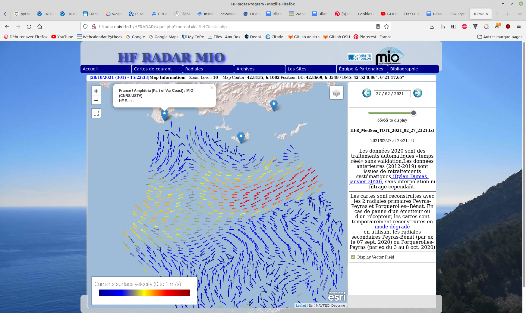
Hourly High Frequency Radar (HFR) surface current data (ocean surface velocity) from 2 different stations located on the French Mediterranean coast (Toulon), processed in real time. The total velocity is then reconstructed from the filled radial velocity files, and projected onto a cartesian grid of 1km x 1km. The HFR data comes from two systems, one monostatic radar PEY (located at Fort Peyras, La Seyne sur mer), and one bistatic POB (receiver located at Cap Bénat - Bormes les Mimosas, and transmitter on Porquerolles Island). The HFR data is initially hourly sampled. The radial velocity are processed by an algorithm of Directional of Arrival Finding with a self-calibration method developed by our laboratory. HF radar sites : - Peyras : 43°03'47.4"N, 5°51'40.3"E - Porquerolles (transmitter only): 42°58'59.0"N, 6°12'15.3"E - Bénat (receiver only): 43°05'31.5"N, 6°21'26.5"E EUROPEAN DIRECTORY OF MARINE ENVIRONMENTAL RESEARCH PROJECTS (EDMERP) : - SICOMAR PLUS(12402), IMPACT(12271), MOOSE(11574), and JERICO NEXT(12227) EQUIPEMENTS: - High Frequency Surface Wave radar WERA from HELZEL MESSTECHNIK PARAMETERS: - sea surface current Citation: - Dylan Dumas, Charles-Antoine Guerin, Self-calibration and antenna grouping for bistatic oceanographic High-Frequency Radars,2020, https://arxiv.org/abs/2005.10528
-
SITE D’ETUDE – Baie de Marseille 05° 17' 30 E - 43° 14' 30 N (3 milles de la côte) PROGRAMME DE RATTACHEMENT - SNO SOMLIT - Infrastructure de Recherche ILICO RESPONSABLE LOCAL: - Gerald Gregori (MIO) - Patrick Raimbault (MIO), jusqu'en 2023 RESPONSABLE NATIONAL : - Nicolas Savoye (Université Bordeaux) OBJECTIF – Thématique générale Les objectifs spécifiques sont, grâce à l’observation systématique et coordonnée au niveau national : 1. d’homogénéiser l’acquisition d’un corps de paramètres (hydro-climatiques, chimiques et biologiques) communs à tous les sites et rendre disponibles les données à l’ensemble de la communauté, afin de ; 2. de permettre une étude comparée de séries à long terme sur les 3 façades du littoral français (identification de fluctuations communes aux différents sites et réponses du littoral à des forçages climatiques ou anthropiques globaux - distinction entre ces deux sources de variabilité) ; EQUIPEMENTS : Capteurs température, salinité, pression = CTD SBE 19 Capteur fluorescence Capteurs oxygène Transmissiomètre Instruments de laboratoire PARAMÈTRES LABELLISES MESURES : Profils 0 – 55 m température, salinité, oxygène, fluorescence Sur prélèvement à 3 niveaux : oxygène, pH, matières en suspension, nutriments, matière particulaire (CHN), isotope stable 13C/15N, chlorophylle, communautés microbiennes (cytométrie en flux); communautés phytoplanctoniques et zooplanctoniques PARAMÈTRES NON LABELLISES MESURES : Abondance et diversité du phytoplancton et du zooplancton DISPONIBILITÉ DES DONNÉES Site web = https://www.somlit.fr/ Base de données SOMLIT : https://www.somlit.fr/visualisation-des-donnees/ Base de données PHYTOCOM - RESOMAR PERSONNELS DÉDIÉS : M. Didry (Tech univ) : sorties en mer et traitement échantillons J.M. Feuerstein (Tech univ) : sorties en mer et traitement échantillons F. Garcia (Ing Univ.) : Soutien logistique pour les mesures en mer V. Lagadec (Ing Univ) : analyses chimiques S. Nunige (Ing CNRS) : analyses chimiques – Responsable Qualité pour la station de Marseille G. Grégori (CR CNRS) : référent scientifique personnels retraités aillant participé aux mesures SOMLIT (avant 2024): M. Lafont (Tech univ) : sorties en mer et traitement échantillons N. Garcia (Ing CNRS) : analyses chimiques – Responsable Qualité P. Raimbault (DR CNRS) : analyses isotopiques PARTENAIRES : Réseau SOMLIT – Suivi DCE – RESOMAR (INSU)
-

Hourly High Frequency Radar (HFR) surface current data (ocean surface velocity) from 2 different stations located on the French Mediterranean coast (Toulon), reprocessed. The total velocity is then reconstructed from the filled radial velocity files, and projected onto a cartesian grid of 1km x 1km. The HFR data comes from two systems, one monostatic radar PEY (located at Fort Peyras, La Seyne sur mer), and one bistatic POB (receiver located at Cap Bénat - Bormes les Mimosas, and transmitter on Porquerolles Island). The HFR data is initially hourly sampled. The radial velocity are processed by an algorithm of Directional of Arrival Finding with a self-calibration method developed by our laboratory. Total velocities are derived using least square fit that maps radial velocities measured from individual sites onto a cartesian grid. The final product is a map of the horizontal components of the ocean currents on a regular grid in the area of overlap of two or more radar stations. Each radar station produces radial velocities map using an hybrid method mixing Beam Forming and Direction Finding according the algorithms described in - New Signal Processing Techniques for Phased-Array Oceanographic Radars: Self-Calibration, Antenna Grouping, and Denoising - https://doi.org/10.1175/JTECH-D-22-0064.1 HF radar sites : - Peyras : 43°03'47.4"N, 5°51'40.3"E - Porquerolles (transmitter only): 42°58'59.0"N, 6°12'15.3"E - Bénat (receiver only): 43°05'31.5"N, 6°21'26.5"E EUROPEAN DIRECTORY OF MARINE ENVIRONMENTAL RESEARCH PROJECTS (EDMERP) : - SICOMAR PLUS(12402), IMPACT(12271), MOOSE(11574), and JERICO NEXT(12227) EQUIPEMENTS: - High Frequency Surface Wave radar WERA from HELZEL MESSTECHNIK PARAMETERS: - sea surface current Citation: - Dylan Dumas, Charles-Antoine Guerin, Self-calibration and antenna grouping for bistatic oceanographic High-Frequency Radars, 2020, https://arxiv.org/abs/2005.10528 - Dylan Dumas, Charles-Antoine Guerin, New Signal Processing Techniques for Phased-Array Oceanographic Radars: Self-Calibration, Antenna Grouping, and Denoising, 2023, https://doi.org/10.1175/JTECH-D-22-0064.1
-
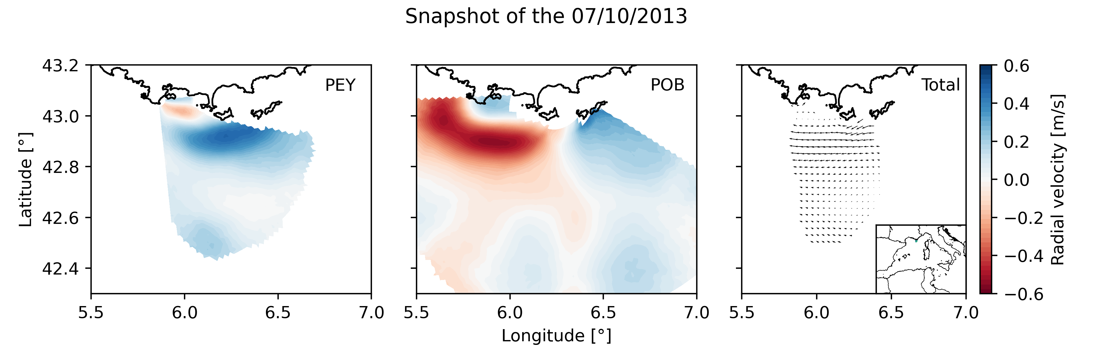
Daily High Frequency Radar (HFR) surface current data (radial velocity files and total velocity file) from 2 different stations located on the French Mediterranean coast (Toulon), spanning from January 2012 to December 2019. The radial datasets have been processed to remove outliers. Then, the gaps in the data have been filled using the DINEOF algorithm. The total velocity is then reconstructed from the filled radial velocity files, and projected onto a cartesian grid of 1km x 1km. The HFR data comes from two systems, one monostatic radar PEY (located at Fort Peyras, La Seyne sur mer), and one bistatic POB (emitter located at Cap Bénat - Bormes les Mimosas, and transmitter on Porquerolles Island). The HFR data is initially hourly sampled. To remove the outliers of the data, for each timestep, a Probability Density Function (PDF) is computed on the spatial gradient of each radial map. Pixels with a spatial gradient with a probability under 3% are removed. Additionnally, for each pixel, a PDF is computed on the temporal gradient of its whole timeseries. Timesteps with a temporal gradient that have a probability under 1% are then removed. Then we proceed to a preliminary temporal and spatial hole filling of the missing data. For the timeseries of each pixel, timesteps that are surrounded by valid values within 3 hours (i.e. 3 timesteps) are filled by a weighted linear interpolation. For each timestep, pixels of the map surrounded by values within 1 grid point are filled in the same way. The radial data is then daily averaged. The DINEOF algorithm (https://orbi.uliege.be/bitstream/2268/87104/1/IMDIS_alvera30sep.pdf) is run in a multivariate way (2 radial velocity files) using 50 EOF modes for the reconstruction. At some timesteps (shown by the flag variable of the file), the filling has not been possible, and the missing maps have been replaced by the temporal average radial map. The filled radial velocities are then locally interpolated onto a cartesian grid of 1km spatial resolution using a Weighted Least Square method. HF radar sites : - Peyras : 43°03'47.4"N, 5°51'40.3"E - Porquerolles (transmitter only): 42°58'59.0"N, 6°12'15.3"E - Bénat (receiver only): 43°05'31.5"N, 6°21'26.5"E EUROPEAN DIRECTORY OF MARINE ENVIRONMENTAL RESEARCH PROJECTS (EDMERP) : - SICOMAR PLUS(12402), IMPACT(12271), MOOSE(11574), and JERICO NEXT(12227) EQUIPEMENTS: - High Frequency Surface Wave radar WERA from HELZEL MESSTECHNIK PARAMETERS: - sea surface current Citation: Molcard, A., & Bourg, N. (2021). HF RADAR - French Riviera (Mediterranean Institute of Oceanography) - daily surface currents filled with DINEOF [Data set]. MIO UMR 7294 CNRS. https://doi.org/10.34930/9263C4DF-4F55-4C5A-B183-C40EE1D844B1
-
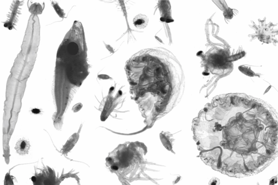
This series is part of the long-term planktonic monitoring of Marseille Oceanographic Laborarories (successively Centre Océanographique de Marseille, Laboratoire d’Océanographie Biologique, Laboratoire d’Océanographie Physique et Biogéochimique, and presently Mediterranean Institute of oceanography / OSU Pytheas ). It aims at describing the dynamics of the mesozooplankton community both in term of biomass and taxonomic groups. This dataset contains the planktonic organisms collected by a WP2 net (Diameter 55 cm; Length : 3 m; Mesh size: 200μm mesh) and therefore covering zooplanktonic organisms from 200µm to ~2cm. The sampling is carried out twice a month at a fixed station in the center of the bay of Marseille (43.2417°N; 5.29167°E) with a depth of 60m (see https://www.somlit.fr/marseille/ ). The WP2 net (200μm mesh) is hauled vertically from 55 to the surface. Sample preserved in 4% buffered formalin and stored over the long term at the MIO. Sample have bee scanned on a ZooScan, images processed with ZooProcess and sorted taxonomically on Particle Trieur, within the Plateforme Microscopie et IMagerie (MIM). The data collection and processing has been funded by several projects over its lifetime. It is currently supported directly by the Mediterranean Institute of oceanography (MIO), as part of its long-term monitoring effort associated with SOMLIT. (https://www.somlit.fr/marseille/) Citation Carlotti F., Guilloux L., Garcia T., Nowaczyk A., Riandey V., Diéval E., Morsly K., Chen, C.T., Neffati N., Lebourg B., Dron A. (2023). Zooplankton timeseries Marseille bay [Data set]. MIO UMR 7294 CNRS. https://doi.org/10.34930/6DA3237C-4732-4C71-B7F1-140C7B2DCDAA
 OSU Pytheas - Data Catalog