OSU Pytheas - Data Catalog
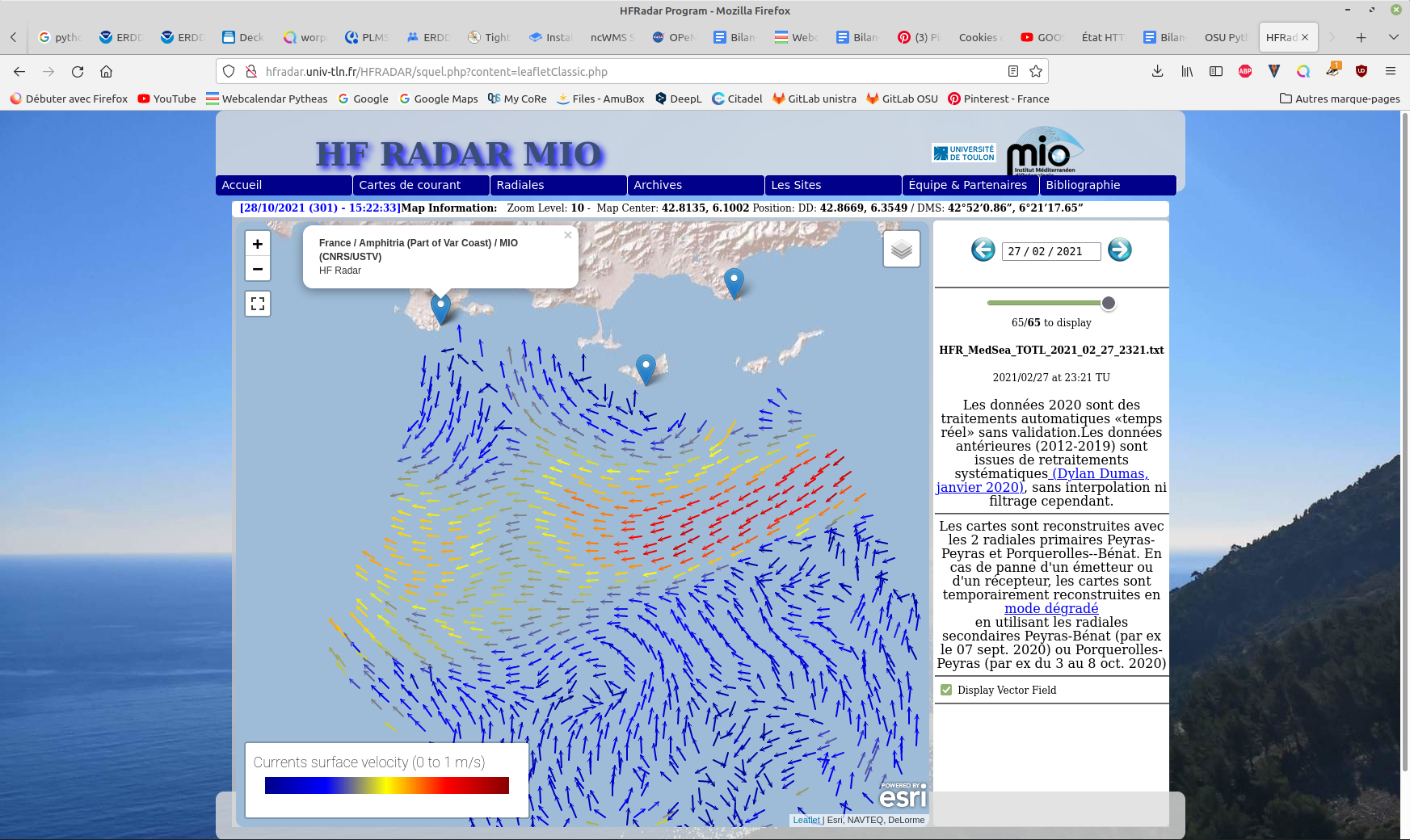
HF RADAR - French Riviera (Mediterranean Institute of Oceanography) - hourly surface currents processed in real-time
Hourly High Frequency Radar (HFR) surface current data (ocean surface velocity) from 2 different stations located on the French Mediterranean coast (Toulon), processed in real time.
The total velocity is then reconstructed from the filled radial velocity files, and projected onto a cartesian grid of 1km x 1km.
The HFR data comes from two systems, one monostatic radar PEY (located at Fort Peyras, La Seyne sur mer), and one bistatic POB (receiver located at Cap Bénat - Bormes les Mimosas, and transmitter on Porquerolles Island). The HFR data is initially hourly sampled. The radial velocity are processed by an algorithm of Directional of Arrival Finding with a self-calibration method developed by our laboratory.
HF radar sites :
- Peyras : 43°03'47.4"N, 5°51'40.3"E
- Porquerolles (transmitter only): 42°58'59.0"N, 6°12'15.3"E
- Bénat (receiver only): 43°05'31.5"N, 6°21'26.5"E
EUROPEAN DIRECTORY OF MARINE ENVIRONMENTAL RESEARCH PROJECTS (EDMERP) :
- SICOMAR PLUS(12402), IMPACT(12271), MOOSE(11574), and JERICO NEXT(12227)
EQUIPEMENTS:
- High Frequency Surface Wave radar WERA from HELZEL MESSTECHNIK
PARAMETERS:
- sea surface current
Citation:
- Dylan Dumas, Charles-Antoine Guerin, Self-calibration and antenna grouping for bistatic oceanographic High-Frequency Radars,2020, https://arxiv.org/abs/2005.10528
Simple
- Date (Publication)
- 2021-10-27T15:00:00
- Citation identifier
- http://dataset.osupytheas.fr/geonetwork/srv/resources7d538d6b-dd15-42af-9de7-c9eac27a840d
- Purpose
-
HF radar sea surface current hourly processed in real time
- Status
- On going
- Maintenance and update frequency
- Not planned
-
GEMET - Concepts, version 2.4
-
-
ocean
-
environment
-
geophysical environment
-
spatial distribution
-
in situ
-
data analysis
-
radar
-
- Keywords
-
-
Continents, countries, sea regions of the world.
-
-
Ligurian Sea
-
Mediterranean Sea, Western Basin
-
- Theme
-
-
sea surface current
-
- Access constraints
- License
- Use constraints
- otherRestictions
- Spatial representation type
- Text, table
- Denominator
- 5000
- Language
- English
- Character set
- UTF8
- Topic category
-
- Oceans
- Environment
- Begin date
- 2019-09-01
- End date
- 2099-12-31
- Description
-
Mediterranean Sea
))
- Supplemental Information
-
Toulon
- Reference system identifier
- WGS 1984
- Distribution format
-
-
Relational database SQL
(
1.0
)
-
Relational database SQL
(
1.0
)
- OnLine resource
-
HF radar web site (Université de Toulon)
(
WWW:LINK-1.0-http--link
)
HF radar website with visualization of near real time data
- OnLine resource
- HF radar hourly processed in near real time ( WWW:LINK-1.0-http--link )
- OnLine resource
- Digital Object Identifier (DOI) ( DOI )
- Hierarchy level
- Dataset
- Statement
-
WERA (Wellen Radar - Helzel Messtechnik GmbH) operated at 16.1-16.2 MHz with 50 kHz bandwidth (3km range resolution) and 8 receiving antennas from 2011 to 2018 on each sites and upgraded to 12 receiving antenna on Benat in 2018 with a better resolution of 1.5 km with 100 KHz of bandwidth.
More details of the installation and acquisition protocols can be found on the real-time dedicated web site http://hfradar.univ-tln.fr/ and in Quentin et al. 2014.7th EuroGOOS Conference Proceedings, Oct 2014, Lisboa, Portugal Buch E, Antoniou Y, Eparkhina D, Nolan G (Eds.) ISBN 978-2-9601883-1-8, pp 111-118.
- File identifier
- 2cbbe040-32a9-47a3-ae1b-c23aa18b9320 XML
- Metadata language
- English
- Character set
- UTF8
- Hierarchy level
- Dataset
- Hierarchy level name
-
dataset
- Date stamp
- 2022-10-06T14:16:43
- Metadata standard name
-
ISO 19115:2003/19139
- Metadata standard version
-
1.0
Overviews
Spatial extent
Provided by