 OSU Pytheas - Data Catalog
oceans
Type of resources
Available actions
Topics
INSPIRE themes
Keywords
Contact for the resource
Provided by
Formats
Representation types
Update frequencies
status
Scale
-
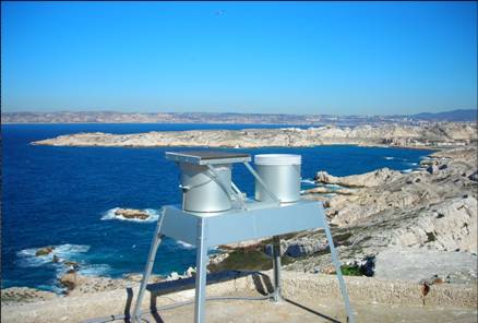
OBJECTIF – Mesures des flux de matières d’origine atmosphérique en mer Méditerranée dans le cadre du réseau MOOSE Mesures en réseau avec cap Béar et cap ferrat Le milieu marin est de plus en plus soumis à l’influence anthropique, très directement sur la frange littorale, mais également au large par les retombées atmosphériques qui peuvent se propager très loin. La Méditerranée étant une mer oligotrophe, c’est-à-dire pauvre en élément nutritifs, tout apport d’éléments peut être un facteur de développement biologique significatif. Par contre l’apport de contaminants et de polluants par voie atmosphérique peut être un facteur perturbant ou inhibant l’écosystème. Le site du Frioul offrant l’opportunité de quantité les retombées atmosphériques dans la zone côtière, le Service d’Observation du MIO a proposé d’utiliser ce site pour installer des collecteurs de retombées atmosphériques. Collecteur de retombées atmosphériques sèches et pluies (MTX Italia) installé sur une plateforme dans l’enceinte du sémaphore de Pomègues Un collecteur de type MTX permet de récupérer les retombées sèches et les retombées humides (pluies) séparément. Parallèlement, un système de pompage en continu des aérosols a été mise en place dans la pièce supérieure du sémaphore. Il est composé de pompes à vide reliées à un compteur qui aspire en continu l’air qui est filtré sur un filtre disposé à l’extérieur. La collecte des échantillons est assurée chaque semaine par un opérateur du MIO. Par ailleurs le MIO assure le traitement et l’analyse de la matière récoltée. Les éléments suivants, source de fertilisation du milieu marin sont déterminés : - Azote total - Phosphore total - Carbone total - Formes solubles de l’azote (nitrate, nitrite, ammonium) - Formes solubles du phosphore (orthophosphates) - Formes particulaires de l’azote, du phosphore et du carbone. SITE : Iles de Pomègues - Sémaphore du Frioul PROGRAMME DE RATTACHEMENT - Mediterranean Oceanic Observing System on Environment : MOOSE - Labellisation : SOERE - INSU - Financement : SOERE – INSU – Ville de Marseille RESPONSABLE LOCAL: - Patrick Raimbault DISPONIBLITE DES DONNEES : - Base de données SEDOO: http://mistrals.sedoo.fr/MOOSE/ PARTICIPANTS : - M. Fornier : collecte - V. Lagadec analyses chimiques - P. Raimbault : analyses élémentaires PARTENAIRES - MOOSE - CHARMEX- Ville de Marseille – Parc des îles du Frioul - OSU de Villefranche et de Banyuls
-

In the framework of the SNO/SOERE MOOSE (Mediterranean Ocean Observing System on Environment https://www.ir-ilico.fr/Les-reseaux-elementaires/Fiches-d-identite-des-reseaux-elementaires/MOOSE ) program, the Mediterranean Institute of Oceanography is operating coastal High Frequency Surface Wave Radars (HF radar) on the North Western Mediterranean coast. This activity is also supported by the following European Research Infrastructure Jerico-Next (https://www.jerico-ri.eu), and Intereg MED programs as Impact and Sicomar +. HF radar provide high resolution (3-5 km), synoptic view of surface currents from the shore up to 80 km off shore at hourly time scales. The measurement principle is based on the Doppler effect created by an additional current on the intrinsic speed of the waves selected by radar-sea interactions, called Bragg waves, having a wavelength of half that of the radar e.m. waves and propagating in the axis of observation (radial currents). A single radar scans the sea in azimuth and determines the radial components of the current at each adjacent cell along each azimuth. Two separate radars for the same area from different angles then collect the information necessary for mapping vector current from the combination of the two sets of radial components. The HF radar data set is made of monthly averaged surface currents, geo-referenced on cartesian lon/lat coordinates. The radial velocities maps are provided applying a Direction Finding technique (instead of traditional Beam Forming) not only to the full array of antenna but also to subarrays made of a smaller number of sequential antennas, a method which we refer to as "antenna grouping". Radials from Peyras-Peyras and Porquerolles-Benat are computed to reconstruct the vector field.
-
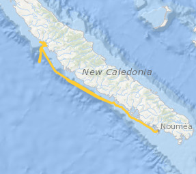
Le projet interdisciplinaire UECOCOT vise à développer des outils d'aide à la gestion durable des activités minières afin de permettre la meilleure cohabitation possible entre dynamique naturelle des environnements (et leur capacité de résistance aux dommages et de résilience) et les activités humaines (industrielles ou non). L'objectif global du projet est de répondre à la question " comment adapter , à un coût socio-économique acceptable, les activités minières pour que leur impact reste compatible avec la durabilité des écosystèmes côtiers et littoraux". Pour atteindre un tel objectif, le projet UECOCOT repose sur une approche multi-sites ayant des impacts miniers différents. Dans le Pacifique sud, le site choisi est le lagon de Koné (Nouvelle-Calédonie) à proximité duquel s'est implanté une mine de nickel et touché par des apports de particules riches en éléments métalliques (Ni, Cr, Co, Mn) issues de l'altération des massifs miniers latéritiques développés sur des péridotites. C'est dans ce cadre qu'a eu lieu en février 2018 une campagnes océanographique multidisciplinaire dans le lagon de Koné dont l'objectif était d'acquérir des informations sur : i) les flux hydrodynamiques et biogéochimiques entre la côte, le lagon et l'océan et les connectivités au sein même du lagon, ii) l'état écologique du lagon et son fonctionnement End to End (hydro-bio-géochimique) , iii) les apports miniers directs ou indirects (avec un focus sur les métaux) et leur impact sur le fonctionnement biogéochimique. L'ensemble des résultats acquis doit permettre de valider un modèle numérique de biologie intégrant les aspects physiologiques et comportementaux des organismes (plancton et benthos) liés à la contamination du milieu et à la circulation hydrodynamique au sein du lagon. Il doit en particulier aboutir à une meilleure compréhension du rôle de la barrière récifale sur la régulation hydrodynamique et ainsi permettre d'affiner les prévisions en terme de contamination du lagon suite à une modification de la structure récifale sous l'effet conjugué de contraintes anthropiques et climatiques. Ce projet s'inscrit dans le réseau international AMEDEE (Activité Minière, Environnement, Développement Economique, Ethiques) qui regroupe les programmes de R&D de 40 institutions scientifiques (Colin, 2016)
-
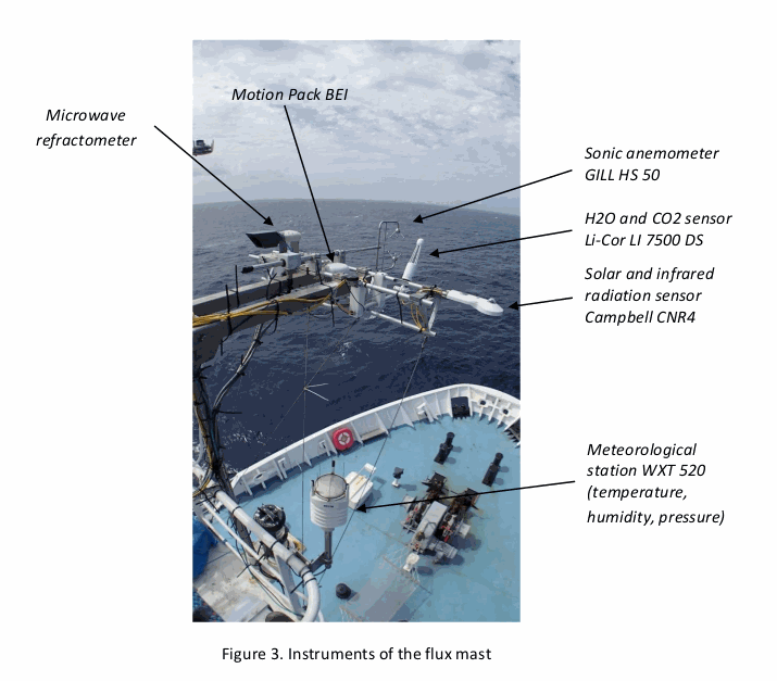
As part of the EUREC4A-OA project (H. Bellenger, S. Speich, LMD), which is the French oceanographic component of the larger EUREC4A field experiments, the “flux mast” national instrument was installed on the Reseach Vessel R/V Atalante from Genavir. The flux mast holds instruments that measure atmospheric turbulence and meteorological variables. The collected data are used to estimate the turbulent fluxes of momentum and heat at the air-sea interface. Specifically, the flux mast instruments measure air pressure, air temperature, humidity, air refraction index, H2O, the three components of the wind vector, and the upward and downward solar and infrared radiation fluxes. The fluxes calculated are the latent and sensible heat fluxes, and the friction velocity. DOI : https://www.seanoe.org/data/00661/77341/
-
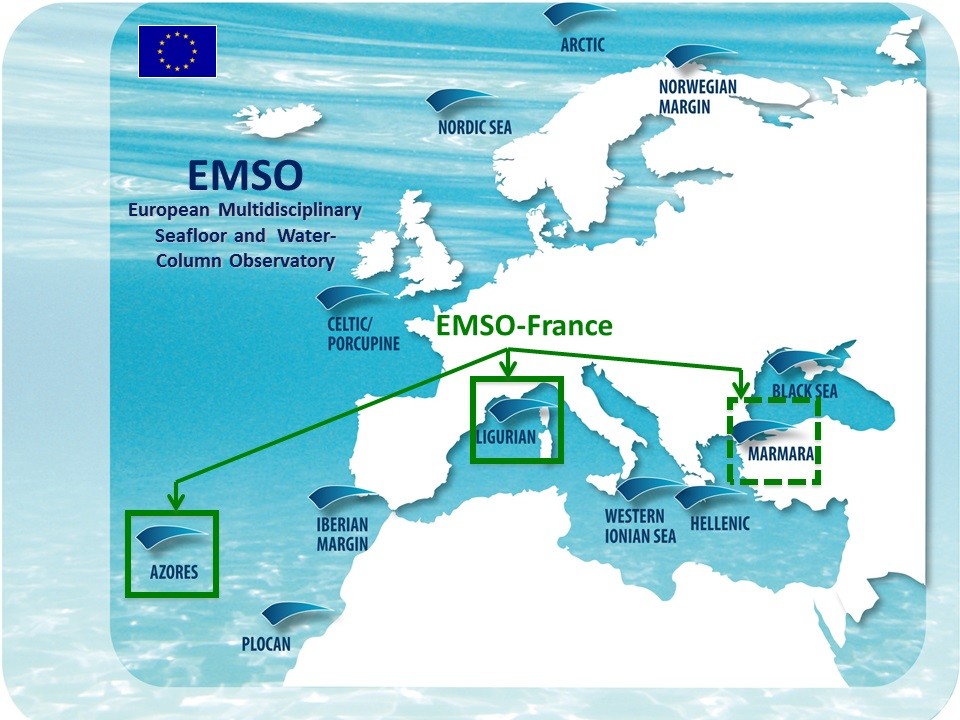
EMSO is a European network of seabed and fixed-point water column observatories whose scientific objective is to acquire long time series in the seas around Europe for the study of environmental processes related to interactions between geosphere, biosphere and hydrosphere. MAREGAMI project (MARine Earthquake Gap Assessment and Monitoring for Istanbul) is a bilateral Turkish-French collaborative project coordinated by IFREMER and Istanbul Technical University and funded by ANR and TÜBITAK. The goal of MAREGAMI is the development of new methods and monitoring strategies to assess earthquake and tsunami risks related to offshore faults, it comprises four tasks: (1) Marine geodesy: acquisition and processing of geodetic submarine data, (2) Hydrodynamics and specific depositional processes: water column data acquisition and hydrodynamic modeling, (3) Improving earthquake relocation with ocean bottom instruments, (4) Designing an optimal and sustainable network of submarine sensors. Data distributed on this portal were acquired for Task 2. The acquisition and distribution of marine data time series in the Sea of Marmara is funded by EMSO-France Research Infrastructure, EMSO-Link, and MAREGAMI projet. DT-INSU provided operational support and instrumentation
-
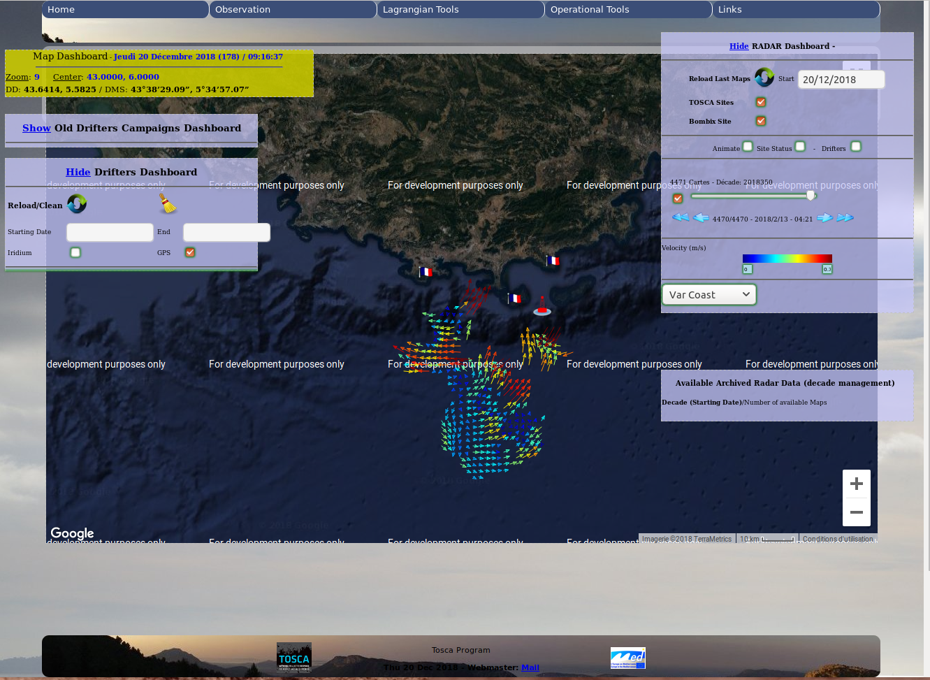
Couplage des données issues des Radar HF et des flotteurs pour améliorer la prévision des dérives des nappes pétrolières et les secours en mer. Le projet TOSCA consiste à développer un réseau côtier de surveillance continue et de prévisions basé sur des radars HF et des instruments et modèles de dérive de nouvelle génération, visant à optimiser la réponse des autorités locales aux accidents de mer, en mettant un accent particulier sur la pollution par les déversements d'hydrocarbures et la recherche. et opérations de sauvetage (SAR). Le projet TOSCA (réseau de surveillance des déversements d’hydrocarbures et des zones côtières) est cofinancé par le Fonds européen de développement régional dans le cadre du programme MED. Il vise à améliorer la qualité et l'efficacité du processus décisionnel en cas d'accident maritime concernant la pollution par les déversements d'hydrocarbures et les opérations de recherche et de sauvetage (SAR) en Méditerranée. Cela se fera avec l'aide d'un réseau comprenant les autorités locales, les décideurs politiques et des scientifiques, dotés d'un système de surveillance et de prévisions maritimes scientifiques et de la mise en œuvre d'outils d'aide à la décision et de plans d'action. TOSCA project consists in the development of a coastal continuous monitoring & forecasting network based on HF radars & new generation drifting instruments & models, aimed at optimizing the response of local authorities to marine accidents, with a special emphasis on oil spill pollution & on search-and rescue (SAR) operations. The TOSCA (Tracking Oil Spills & Coastal Awareness network) project is cofinanced by the European Regional Development Fund in the framework of the MED Programme. It intends to improve the quality and effectiveness of decision-making process in case of marine accidents concerning oil spill pollution and search and rescue (SAR) operations in the Mediterranean.This will be done with the help of a network including local authorities, policy makers and scientists, with a scientific maritime monitoring and forecasting system and with the implementation of decision support tools and action plans.
-
JULIO (Judicious Location for Intrusions Observations) mooring is located close to the 100 m-deep isobath (around 5.25°E and 43.13°N), offshore Marseille. With its bottom-moored (300kHz) ADCP, it enables measuring horizontal currents (every 4 m and every ½ h) through the water column, and among others, identifying periods of exchange between the Northern Current and the continental shelf. It is one crucial component in the study of the coastal-offshore gradient from Marseille to the MOOSE 42°N5°E station, and potential covariances with the MIO radar and other MIO or international observing systems, as well as with the SOMLIT site (including also an ADCP) in the bay of Marseille. Moreover, with a bottom CTD, it can detect environmental anomalies in classical hydrographic data, useful for oceanographers. As one of the rare station at the interface between the continental shelf and offshore, it will allow to observe the long-term evolution of the Northern Current in the context of climate change and anthropogenic pressure, and its potential varying impact on the Gulf of Lion. The data are of course also crucial for modellers. Moreover they show a great potential when supplementing other MOOSE data (glider and radar). Timeserie #3 : - JULIO 3 - 17/07/2014 to 10/04/2015; JULIO (Judicious Location for Intrusions Observations) est situé à proximité de l'isobathe de 100 m de profondeur (environ 5,25°E et 43,13°N), au large de Marseille. Grâce à son ADCP (300 kHz), il permet de mesurer les courants horizontaux (tous les 4 m et toutes les ½ h) à travers la colonne d'eau et, entre autres, d'identifier les périodes d'échange entre le courant du Nord et le plateau continental. Il s'agit d'un élément crucial dans l'étude du gradient littoral-offshore de Marseille à la station MOOSE 42°N5°E, et des covariances potentielles avec le radar MIO et autres systèmes d'observation MIO ou internationaux, ainsi qu'avec le site SOMLIT (incluant également un ADCP) dans la baie de Marseille. De plus, avec un CTD de fond, il peut détecter les anomalies environnementales dans les données hydrographiques classiques, utiles aux océanographes. En tant qu'une des rares stations à l'interface entre le plateau continental et le large, elle permettra d'observer l'évolution à long terme du courant du Nord dans le contexte du changement climatique et de la pression anthropique, et son impact potentiel variable sur le Golfe du Lion. Les données sont bien sûr également cruciales pour les modélisateurs. De plus, ils présentent un grand potentiel en complément d'autres données MOOSE (planeur et radar). Série temporelle #3 : - JULIO 3 - 17/07/2014 to 10/04/2015;
-
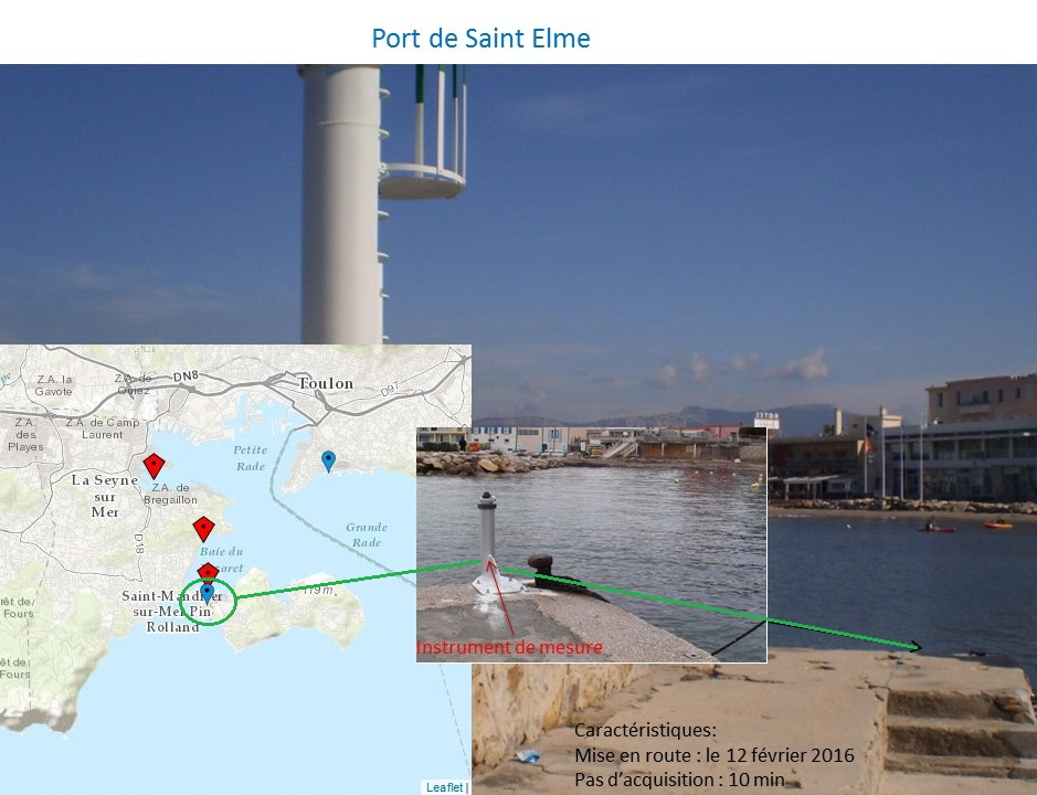
Acquisition automatique sur le long terme et en temps réel de données de niveau d'eau et de température le long du littoral Varois (France) Le programme consiste à apporter des données de mesures originales pour une meilleure compréhension et modélisation des interactions et couplages entre la dynamique côtière et la dynamique littorale à l'échelle des baies (actuellement aire de l'agglomération toulonnaise avec projet d'extension à plus grande échelle le long de la côte méditerranéenne), par le développement d'un système d'observation sur le long terme (plusieurs années). Il est à l'interface des axes de recherche en dynamique du plateau continental et en dynamique littorale du laboratoire MIO, composante de l'Observatoire des Sciences de l'Univers PYTHEAS.
-
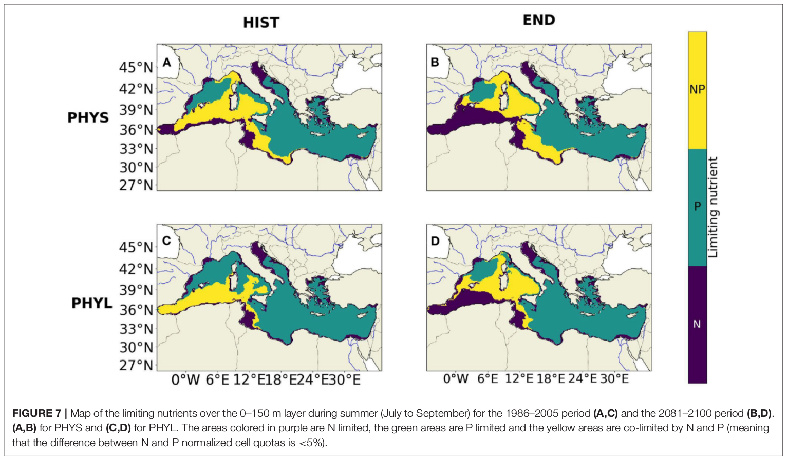
"Towards an integrated prediction of Land & Sea Responses to global change in the Mediterranean Basin" The LaSeR-Med project aims at investigating the effects of climate change and of mediterranean population growth on some major indicators of the Mediterranean Sea (primary production, carbon export, zooplankton biomass available for small pelagic fishes, pH, dissolved oxygen) using and integrated model encompassing a socio-economic model, a continental model of agro-ecosystems, and a physical ocean-atmosphere model coupled to a biogeochemical model of the ocean. Last, a model for the widespread species of jellyfish Pelagia Noctiluca (Berline et al., 2013) uses biogeochemical outputs as food forcing for the jellyfish. In this project, our aim was first to investigate the large-scale and long-term impacts of variations in river inputs on the biogeochemistry of the Mediterranean Sea over the last decades (see Pages et al., 2020a). In the second phase, a climate scenario (RCP8.5) alone (Pages et al., 2020b) or combined with a “land-use” scenario derived to ensure the same level of food availability as today in 2050 have been run to investigate its effect on these indicators and to analyze the observed changes on the structure and the functioning of planktonic food web. This interdisciplinary project provided the framework for joint discussions on each of the sub-models that constitute the integrated model, namely the socio-economic model (Ami et al., in prep., Mardesic et al., in prep.) created ex nihilo by researchers from AMSE, INRA and GREQAM, the continental agro-ecosystem model LPJmL (Bondeau et al., 2007) worked on at IMBE so as to include the nitrogen and phosphorous cycles in the frame of the present project, and the ocean biogeochemical model Eco3M-Med developed at MIO (Baklouti et al., 2006; Alekseenko et al. 2014, Guyennon et al., 2015; Pagès et al., 2020a), forced by ocean physics, either using the ocean model NEMO-Med12 forced by atmosphere at IPSL (simulation NM12-FREE run with the NEMO-MED12 model and used for our hindcast simulation, see below) or a coupled ocean-atmosphere model at CNRM (physical forcing provided by CNRM-RCSM4, see below). Details on the CNRM-RCSM4 model The CNRM-RCSM4 simulates the main components of the Mediterranean regional climate system and their interactions. It includes four different components: (i) The atmospheric regional model ALADIN-Climate (Radu et al., 2008; Colin et al., 2010; Herrmann et al., 2011) characterized by a 50 km horizontal resolution, 31 vertical levels, and a time step of 1800 s, (ii) the ISBA (Interaction between Soil Biosphere and Atmosphere) land-surface model (Noilhan and Mahfouf, 1996) at a 50 km horizontal resolution, (iii) the TRIP (Total Runoff Integrating Pathways) river routing model (Oki and Sud, 1998), used to convert the runoff simulated by ISBA into rivers (Decharme et al., 2010; Szczypta et al., 2012; Voldoire et al., 2013), and (iv) the Ocean general circulation model NEMO (Nucleus for European Modeling of the Ocean, Madec and NEMO-Team, 2016) in its NEMO-MED8 regional configuration (Beuvier et al., 2010). NEMO-MED8 is characterized by a horizontal resolution of 1/8° (grid cells size from 6 to 12 km), a vertical resolution of 43 vertical levels (cell height ranging from 6 to 200 m), and a time step of 1200 s. More details about the CNRM-RCSM4 model can be found in Sevault et al. (2014). Keywords: - Mediterranean Sea, river inputs, chlorophyll, nutrients, phytoplankton, bacteria, zooplankton, dissolved and particulate organic detrital matter Citation: Pagès, R., Baklouti, M., Barrier, N., Richon, C., Dutay, J.-C., and Moutin, T. (2020a). Changes in rivers inputs during the last decades significantly impacted the biogeochemistry of the eastern Mediterranean basin: a modelling study. Prog. Oceanogr. 181:102242. doi:10.1016/j.pocean.2019.102242 Pagès, R., Baklouti, M., Barrier, N., Ayache, M., Sevault, F., Somot, S. and Moutin, T. (2020b). Projected Effects of Climate-Induced Changes in Hydrodynamics on the Biogeochemistry of the Mediterranean Sea Under the RCP 8.5 Regional Climate Scenario. Front. Mar. Sci. 7:563615. doi:10.3389/fmars.2020.563615 Ayache, M., Bondeau, A., Pagès, R., Barrier, N., Ostberg, S. and Baklouti, M. (2020). LPJmL-Med – Modelling the dynamics of the land-sea nutrient transfer over the Mediterranean region–version 1: Model description and evaluation. Geoscientific Model Development Discussions, Copernicus Publ.
-
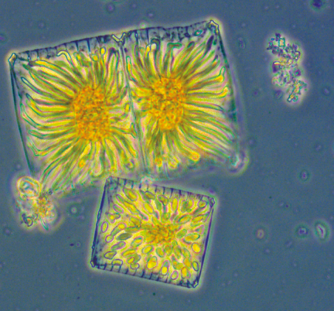
The New Caledonia lagoons show high seasonal and interannual variability (related to El Niño – Southern oscillation – ENSO - variability). They present a great diversity of local situations linked to differences in their geomorphology, to the nature of terrigenous inputs and to varied anthropogenic pressure. This variability impacts the structure of planktonic communities and their biodiversity. The scientific objectives of the CLAPPP project developed on 6 New Caledonia lagoons are : - 1) to describe the local environmental conditions and their seasonality, - 2) to understand the heterogeneity of phytoplankton communities at the biological, spatial and/or temporal levels, - 3) to study the role of this diversity in the functioning of coral ecosystems and the regulation of biogeochemical cycles, and - 4) to assess the importance of phytoplankton as an index of productivity and health of the lagoons in relation with local stress conditions and the risk of HABs. DOI: - https://doi.org/10.34930/2b52defe-e5f3-4fe2-9f2f-741d90e624ea Citation: Rodier, M., & Arfi, R. (2020). CLAPPP - New Caledonian lagoons: Physics and Phytoplankton processes [Data set]. MIO UMR 7294 CNRS. https://doi.org/10.34930/2B52DEFE-E5F3-4FE2-9F2F-741D90E624EA