OSU Pytheas - Data Catalog
EMSO / MAREGAMI Marmara
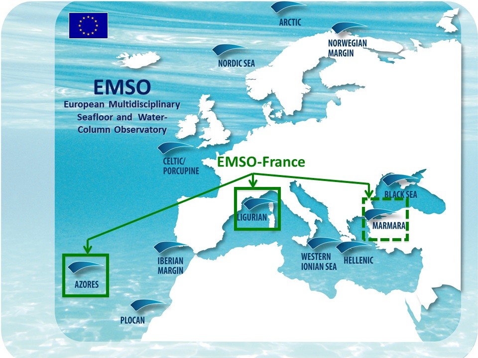
EMSO is a European network of seabed and fixed-point water column observatories whose scientific objective is to acquire long time series in the seas around Europe for the study of environmental processes related to interactions between geosphere, biosphere and hydrosphere.
MAREGAMI project (MARine Earthquake Gap Assessment and Monitoring for Istanbul) is a bilateral Turkish-French collaborative project coordinated by IFREMER and Istanbul Technical University and funded by ANR and TÜBITAK.
The goal of MAREGAMI is the development of new methods and monitoring strategies to assess earthquake and tsunami risks related to offshore faults, it comprises four tasks:
(1) Marine geodesy: acquisition and processing of geodetic submarine data,
(2) Hydrodynamics and specific depositional processes: water column data acquisition and hydrodynamic modeling,
(3) Improving earthquake relocation with ocean bottom instruments,
(4) Designing an optimal and sustainable network of submarine sensors.
Data distributed on this portal were acquired for Task 2.
The acquisition and distribution of marine data time series in the Sea of Marmara is funded by EMSO-France Research Infrastructure, EMSO-Link, and MAREGAMI projet.
DT-INSU provided operational support and instrumentation
Simple
- Date (Publication)
- 2019-01-23
- Citation identifier
- http://gndev.osupytheas.fr/geonetwork/srv/resources7175f88e-cde6-4a67-ada5-1e44a687156f
- Purpose
-
EMSO is a European network of seabed and fixed-point water column observatories whose scientific objective is to acquire long time series in the seas around Europe for the study of environmental processes related to interactions between geosphere, biosphere and hydrosphere.
EMSO est un réseau Européen d'observatoires du fond de mer et de la colonne d'eau au point fixe qui a pour objectif scientifique d'observer en temps réel les processus enviaronnementaux liés avec les interactions entre géosphère, biosphère et hydrosphère.
- Status
- On going
- Maintenance and update frequency
- Irregular
-
GEMET - Concepts, version 2.4
-
-
physical environment
-
environmental data
-
-
GEMET - INSPIRE themes, version 1.0
-
-
Natural risk zones
-
Oceanographic geographical features
-
Sea regions
-
-
Continents, countries, sea regions of the world.
-
-
Sea of Marmara
-
-
UMR_OSU
-
-
CEREGE UMR 7330 CNRS
-
- Keywords
-
-
temperature
-
pression
-
- Access constraints
- Copyright
- Use constraints
- otherRestictions
- Spatial representation type
- Vector
- Denominator
- 5000
- Language
- English
- Character set
- UTF8
- Topic category
-
- Oceans
- Begin date
- 2017-04-15
- End date
- 2020-04-14
- Description
-
Marmara
))
- Supplemental Information
-
You can customize the template to suit your needs.
You can add
and remove fields and fill out default information (e.g. contact
details).
Fields you can not change in the default view may be accessible in the
more
comprehensive (and more complex) advanced view. You can even use the
XML editor
to create custom structures, but they have to be validated by the
system, so
know what you do :-)
- Reference system identifier
- WGS 1984
- Distribution format
-
-
fichiers NetCDF, et CSV
(
1.0
)
-
fichiers NetCDF, et CSV
(
1.0
)
- Protocol
-
WWW:DOWNLOAD-1.0-http--download
- Description
-
MAREGAMI Instrumented frame
- Function
- Information
- OnLine resource
- EMSO Project ( WWW:LINK-1.0-http--link )
- OnLine resource
- Data access to EMSO Maregami Marmara ( WWW:LINK-1.0-http--link )
- Hierarchy level
- Dataset
- Statement
-
Data originate from an instrumented frame deployed for durations of about 6 month at different locations at the bottom of the Sea of Marmara deep basins. The instrumentation is autonomous and comprises (1) a RBR bottom pressure recorder with a Paroscientific 0-2000 m Digiquartz sensor, (2) a Seaguard recording current meter (RCM) equipped with additional sensors: temperature, pressure (tide sensor aandera 5217), conductivity, oxygen (aandera optode). The tide sensor is a piezoresistive sensor of accuracy comparable to that of the Digiquartz sensors (0.02% vs 0.01% for Digiquartz), and 0.2 hPa (2 mm) resolution. The RBR pressure sampling interval was thus set to 5s and the Seaguard RCM to 5 minutes (for all sensors). The RBR system was acquired with MAREGAMI funding, the Seaguard RCM was loaned by DT-INSU, as well as the acoustic release systems, a flasher and an Argos beacon. The tide sensor fit on the Seaguard RCM was acquired with EMSO funding.
- File identifier
- 7175f88e-cde6-4a67-ada5-1e44a687156f XML
- Metadata language
- English
- Character set
- UTF8
- Hierarchy level
- Dataset
- Hierarchy level name
-
dataset
- Date stamp
- 2020-10-23T18:46:02
- Metadata standard name
-
ISO 19115:2003/19139
- Metadata standard version
-
1.0
Overviews
Spatial extent
Provided by