From 1 - 4 / 4
  • Categories  

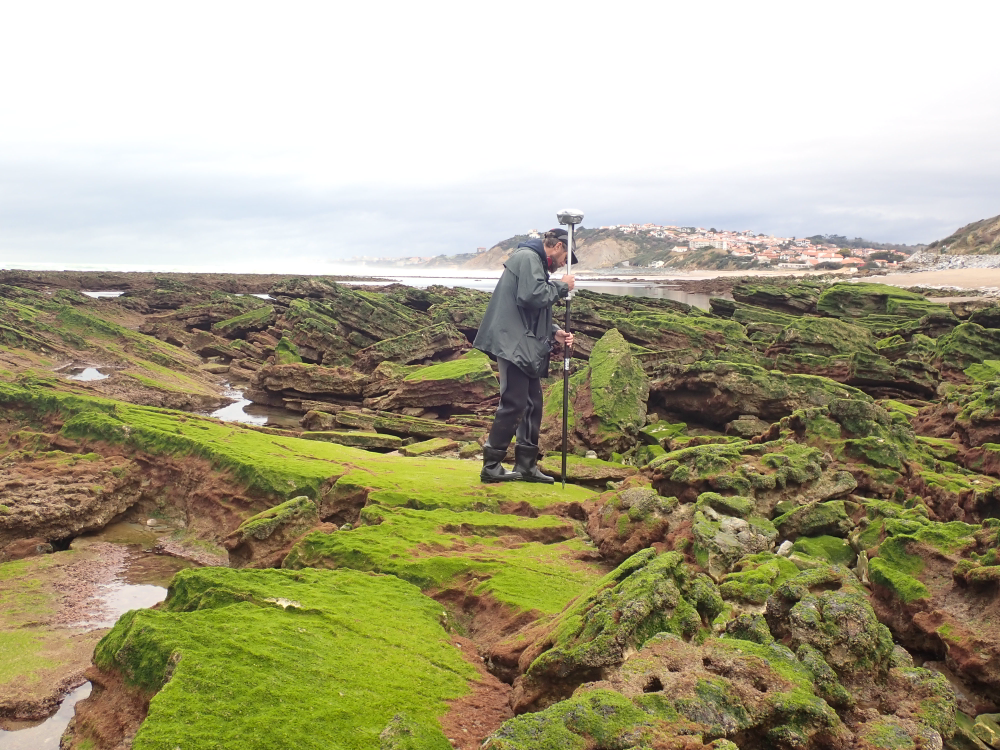
    The present dataset is based on a nine site study of fine seabed topography in intertidal zones. Four coral sites (Maupiti A, B and C and Niau islands) and five rocky sites (Ars en Ré, Socoa, Parlementia A and B and Banneg island) have been explored. The data has been gathered using on-foot GNSS RTK for all sites (Trimble R8/R8S and Leica sytems) except Banneg island, where aerial Lidar data from Litto3D program has been used. The horizontal resolution varies between 3.8 and 12cm allowing to describe a wide range of spatial scales (generally over 3 spectral decades). The data has been processed to explore the statistical and spectral metrics which can be used to characterize the architectural complexity of seabeds. Owners: - Topographic survey on Ars-en-Ré : profile X, Z in meter along a transec was operated on 10-15 Jan 2021 with On-foot Trimble R8/R8S GNSS RTK by Shom, Gladys and Univ. de Montpellier - Topographic survey on Maupiti Hoe: profile X, Z in meter along a transec was operated on 5-10 July 2018 with on-foot Trimble R8/R8S GNSS RTK by GLADYS and Université de Montpellier - Topographic survey on Niau : profile X, Z in meter along a transec operated on 10 Nov. 2021 with On-foot Trimble R8/R8S GNSS RTK - by CEREGE and MIO (OSU Pytheas) - Topographic survey on Parlementia A, and B : profile X, Z in meter along a transec was operated on 22 Fev 2023 with on-foot Leica GNSS RTK by SIAME, UPPA - Topographic survey on Socoa : profile X, Z in meter along a transec was operated on 21 Fev 2023 with on-foot Leica GNSS RTK by SIAME, UPPA and Shom - Topographic survey in high resolution of Banneg island (X, Y, Z) is made by aerial lidar litto3D on spring 2012/2013 by Shom and IGN

  • Categories  

    The scientific objectives of the project MAUPITI HOE are to understand the hydrodynamics of an archetypal reef-lagoon system of a high volcanic reef island. The physical functioning of the hydrosystem involves a fine coupling between water levels, waves (including wind, infragravity and VLF waves), currents and seabed structure (reef roughness). The present data focuses on the reef barrier dynamics. Citation: - Sous D., Bouchette F., Certain R., Meulé S. (2021). Maupiti Hoe 2018 [Data set]. MIO UMR 7294 CNRS, GLADYS. https://doi.org/10.34930/9DB3BEC4-0BBF-4531-8864-F100C4B8ECED

  • Categories  

    Maupiti ("the Stuck Twins'') is a diamond-shaped island located in the western part of the Society archipelago in French Polynesia. The present study focuses on the data recovered over a single cross-barrier transect located in the south-west barrier during the MAUPITI HOE field campaign, from 5 to 18 July 2018. The studied area is representative of the reef structure observed along the 4km-long southwestern barrier reef, showing an alongshore-uniform structure exposed to swell approaching with weak incident angles, a healthy reef colony. In the cross-barrier direction, the reef displays a clear partitioning of bottom roughness that ranges from low-crested compact structures at the reef crest to higher and sparser coral bommies on the backreef. The experimental setup was specifically designed to analyse and differentiate the dynamics over three roughness-contrasting sections found over the barrier reef. The scientific objectives of the project MAUPITI HOE are to understand the hydrodynamics of an archetypal reef-lagoon system of a high volcanic reef island. The physical functioning of the hydrosystem involves a fine coupling between water levels, waves (including wind, infragravity and VLF waves), currents and seabed structure (reef roughness). Four pressure sensors (OSS3, OSS4, OSS5, OSS6) have been deployed across the reef flat/ backreef, outside the surf zone. The bottom pressure is measured continuously at 10 Hz, and are converted into free surface elevation assuming hydrostaticity. An electrocurrent meter S4 provides the wave forcing while AQP1 is a velocity profiler providing the transports. The bed profile is obtained from the combination of (I) boat survey in the deeper part and (ii) high resolution GNSS RTK topography by feet. Two datasets are available: one is concerning the mean parameters linked to the reef barrier dynamics, and the second dataset is concerning the wave friction.

  • Categories  

    Maupiti ("the Stuck Twins'') is a diamond-shaped island located in the western part of the Society archipelago in French Polynesia. The present study focuses on the data recovered over a single cross-barrier transect located in the south-west barrier during the MAUPITI HOE field campaign, from 5 to 18 July 2018. The studied area is representative of the reef structure observed along the 4km-long southwestern barrier reef, showing an alongshore-uniform structure exposed to swell approaching with weak incident angles, a healthy reef colony. In the cross-barrier direction, the reef displays a clear partitioning of bottom roughness that ranges from low-crested compact structures at the reef crest to higher and sparser coral bommies on the backreef. The experimental setup was specifically designed to analyse and differentiate the dynamics over three roughness-contrasting sections found over the barrier reef. Four pressure sensors (OSS3, OSS4, OSS5, OSS6) have been deployed across the reef flat/ backreef, outside the surf zone. The bottom pressure is measured continuously at 10 Hz, and are converted into free surface elevation assuming hydrostaticity. An electrocurrent meter S4 provides the wave forcing while AQP1 is a velocity profiler providing the transports. The bed profile is obtained from the combination of (I) boat survey in the deeper part and (ii) high resolution GNSS RTK topography by feet. S4 position : -16.47109°N; -152.2782°E OSS3 position: -16.46968°N; -152.27698°E OSS4 position : -16.46931°N; -152.27676°E OSS5 position : -16.46851°N;-152.27614°E OSS6 position: -16.46706°N; -152.27504°E AQP1 position: -16.46318°N ; -152.27348°E