OSU Pytheas - Data Catalog
Maupiti Hoe 2018 : High-resolution experimental survey of the Maupiti Island reef-lagoon system - mean parameters
The scientific objectives of the project MAUPITI HOE are to understand the hydrodynamics of an archetypal reef-lagoon system of a high volcanic reef island. The physical functioning of the hydrosystem involves a fine coupling between water levels, waves (including wind, infragravity and VLF waves), currents and seabed structure (reef roughness). The present data focuses on the reef barrier dynamics.
Citation:
- Sous D., Bouchette F., Certain R., Meulé S. (2021). Maupiti Hoe 2018 [Data set]. MIO UMR 7294 CNRS, GLADYS. https://doi.org/10.34930/9DB3BEC4-0BBF-4531-8864-F100C4B8ECED
Simple
- Date (Publication)
- 2021-08-24T11:00:00
- Citation identifier
- http://dataset.osupytheas.fr/geonetwork/srv/resources7d538d6b-dd15-42af-9de7-c9eac27a840d
- Purpose
-
High-resolution experimental survey of the Maupiti Island reef-lagoon system
- Status
- Historical archive
- Maintenance and update frequency
- Not planned
-
GEMET - Concepts, version 2.4
-
-
environment
-
geophysical environment
-
data acquisition
-
spatial distribution
-
monitoring data
-
geo-referenced data
-
environmental analysis
-
environmental research
-
environmental data
-
experiment
-
research project
-
scientific research
-
erosion
-
field experiment
-
hydrosphere
-
geomorphic process
-
sea
-
-
GEMET - INSPIRE themes, version 1.0
-
-
Meteorological geographical features
-
Sea regions
-
-
Continents, countries, sea regions of the world.
-
-
Oceania
-
French Polynesia
-
France
-
- Theme
-
-
coral reef
-
circulation
-
waves
-
bed roughness
-
- Access constraints
- Copyright
- Use constraints
- otherRestictions
- Spatial representation type
- Vector
- Denominator
- 5000
- Language
- English
- Character set
- UTF8
- Topic category
-
- Oceans
- Environment
- Climatology, meteorology, atmosphere
- Geoscientific information
- Begin date
- 2018-07-05
- End date
- 2018-07-19
- Description
-
Southeast Pacific Ocean (140W)
))
- Supplemental Information
-
Maupiti, french polynesia
- Reference system identifier
- WGS 1984
- Distribution format
-
-
relationnal database SQL
(
1.0
)
-
relationnal database SQL
(
1.0
)
- OnLine resource
-
DOI Maupiti_Hoe - wave parameters (Significant Wave Height and Mean Sea Level)
(
DOI
)
The following parameters are recorded : station_id, datetime, latitude, longitude, sea_surface_swell_wave_significant_height sea_surface_infragravity_waves_significant_height, surface_elevation Theses data are every hour.
- OnLine resource
-
Maupiti2018_allstations.csv
(
WWW:DOWNLOAD-1.0-http--download
)
You can download CSV tabular data with comma separator or
NetCDF format file. The following parameters are recorded :
station_id, datetime, latitude, longitude, sea_surface_swell_wave_significant_height sea_surface_infragravity_waves_significant_height, surface_elevation
Theses data are every hour.
- Hierarchy level
- Dataset
- Statement
-
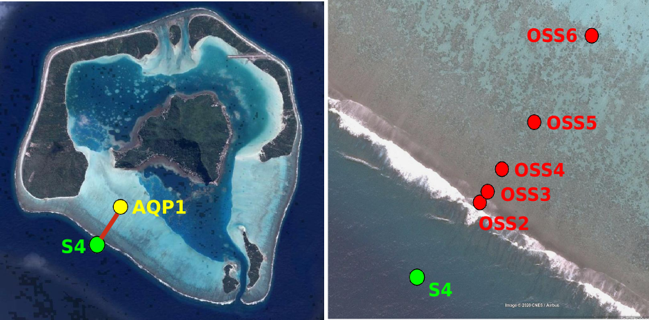
The experimental strategy was to deploy a series of bottom-moored pressure sensors across the reef barrier to study the cross-reef evolution of wave energy and water level and a velocity profiler in the lagoon to quantify the cross-reef transport. The recovered data allowed to estimate the main terms of the wave-averaged depth-averaged momentum balance.
- File identifier
- a0f7b639-e8e0-4b51-8a80-883e60b6fa11 XML
- Metadata language
- English
- Character set
- UTF8
- Parent identifier
-
Maupiti Hoe 2018
9db3bec4-0bbf-4531-8864-f100c4b8eced
- Hierarchy level
- Dataset
- Hierarchy level name
-
dataset
- Date stamp
- 2022-11-15T17:04:14
- Metadata standard name
-
ISO 19115:2003/19139
- Metadata standard version
-
1.0
Overviews

Spatial extent
Provided by