 OSU Pytheas - Data Catalog
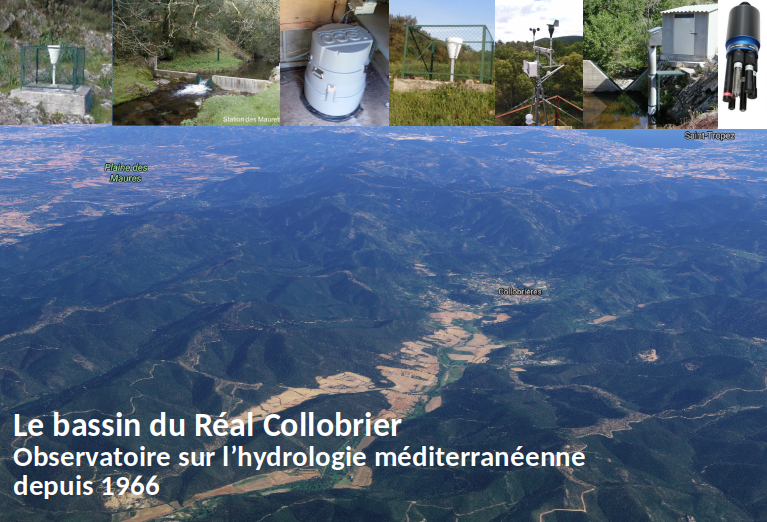
REAL COLLOBRIER The oldest French observatory on Mediterranean hydrology
The observatory of the Réal Collobrier basins was set up in 1967 to improve the knowledge of particular hydrological phenomena in the Mediterranean area. Located in forest and rural areas on metamorphic soils of the Massif des Maures in the Var, it is a landmark of regional hydro-climatology.
This laboratory is used to develop research on improving the knowledge of Mediterranean hydrology, with a monitoring of rainfall (currently 17 raingauges) and flow (7 water level recorders) on a 70 km² basin, since more than 50 years. Since 2015 the watershed has integrated the SOERE RBV and IR OZCAR.
New measuring instruments have been set up (multi-parameter probes, meteorological station, water temperature, automatic sampler, etc.). Scientific objectives around the observatory include the study of flash floods, availability of water resources, study of the interaction between vegetation and the water cycle, knowledge of spatial variability of hydrometeorological processes.
These interdisciplinary research axes call for hydrology, soil physics, geomorphology, hydrogeology and biochemistry contribute to the improvement of knowledge, the development of tools and methods in the field of rainfall and climatology, and also to the improvement of the understanding and the modelling of the flows.
----
L'observatoire des bassins de Réal Collobrier a été créé en 1967 pour améliorer la connaissance de phénomènes hydrologiques particuliers en Méditerranée. Situé en forêt et en milieu rural sur les sols métamorphiques du Massif des Maures dans le Var, il est un repère de l'hydro-climatologie régionale.
Ce laboratoire permet de développer la recherche sur l'amélioration des connaissances en hydrologie méditerranéenne, avec un suivi des précipitations (actuellement 17 pluviomètres) et des débits (7 enregistreurs de niveau d'eau) sur un bassin de 70 km², depuis plus de 50 ans. Depuis 2015, le bassin versant a intégré le SOERE RBV et l'IR OZCAR.
Simple
- Date (Publication)
- 2019-11-25
- Citation identifier
- http://dataset.osupytheas.fr/geonetwork/srv/resources6225ae21-7719-4b02-9e19-a2d5e8934975
- Purpose
-
L'observatoire des bassins de Réal Collobrier a été créé en 1967 pour améliorer la connaissance de phénomènes hydrologiques particuliers en Méditerranée. Situé en forêt et en milieu rural sur les sols métamorphiques du Massif des Maures dans le Var, il est un repère de l'hydro-climatologie régionale.
Ce laboratoire permet de développer la recherche sur l'amélioration des connaissances en hydrologie méditerranéenne, avec un suivi des précipitations (actuellement 17 pluviomètres) et des débits (7 enregistreurs de niveau d'eau) sur un bassin de 70 km², depuis plus de 50 ans. Depuis 2015, le bassin versant a intégré le SOERE RBV et l'IR OZCAR.
- Status
- On going
- Maintenance and update frequency
- Irregular
-
GEMET - Concepts, version 2.4
-
-
environmental data
-
hydrographic basin
-
-
GEMET - INSPIRE themes, version 1.0
-
-
Hydrography
-
Atmospheric conditions
-
Meteorological geographical features
-
-
Continents, countries, sea regions of the world.
-
-
France
-
Mediterranean Region
-
- Theme
-
-
Cycle de l’eau
-
pluviométrie
-
hydrométrie
-
physico-chimie
-
humidité
-
- Access constraints
- Copyright
- Use constraints
- otherRestictions
- Spatial representation type
- Vector
- Denominator
- 5000
- Language
- English
- Character set
- UTF8
- Topic category
-
- Environment
- Begin date
- 1967-01-01
- End date
- 2020-10-05
- Description
-
Mediterranean Sea
))
- Supplemental Information
-
You can customize the template to suit your needs.
You can add
and remove fields and fill out default information (e.g. contact
details).
Fields you can not change in the default view may be accessible in the
more
comprehensive (and more complex) advanced view. You can even use the
XML editor
to create custom structures, but they have to be validated by the
system, so
know what you do :-)
- Reference system identifier
- WGS 1984
- Distribution format
-
-
base de données SQL
(
1.0
)
-
base de données SQL
(
1.0
)
- OnLine resource
-
site web Réal Collobrier
(
WWW:LINK-1.0-http--link
)
Observatoire sur l'hydrologie Méditerranéenne depuis 1966
- Hierarchy level
- Dataset
- Statement
-
Le bassin versant expérimental du Réal Collobrier est situé sur la façade méditerranéenne dans le département du Var, à l’extrémité Ouest du massif montagneux des Maures, à 20 km au Nord-est de Toulon. Avec 17 postes pluviographiques et 11 stations de contrôle de débits répartis sur 70 km2 il constitue un site repère de l’hydro-climatologie régionale depuis 1966.
- Données acquises à pas de temps variables en continue pour 17 postes pluviographiques (pluie),
- 7 stations de contrôle de débits (hauteurs, débits, température de l’eau) répartis sur 70 km2 depuis 1966.
- Acquisition récente de l’humidité du sol télétransmises (5 stations), paramètres physico-chimique de l’eau (2 stations), une station climatique télétransmise.
- File identifier
- 6225ae21-7719-4b02-9e19-a2d5e8934975 XML
- Metadata language
- English
- Character set
- UTF8
- Hierarchy level
- Dataset
- Hierarchy level name
-
dataset
- Date stamp
- 2019-11-29T15:50:10
- Metadata standard name
-
ISO 19115:2003/19139
- Metadata standard version
-
1.0
Overviews
Spatial extent
Provided by
