 OSU Pytheas - Data Catalog
climatologyMeteorologyAtmosphere
Type of resources
Available actions
Topics
INSPIRE themes
Keywords
Contact for the resource
Provided by
Years
Formats
Representation types
Update frequencies
status
Scale
-
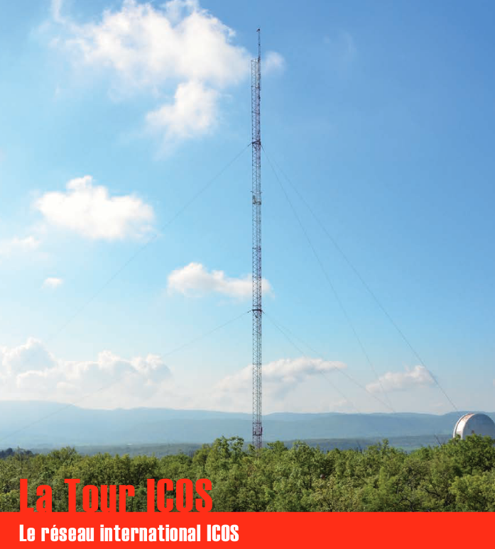
Une infrastructure de recherche européenne de mesure des concentrations atmosphériques des gaz à effet de serre et des flux de carbone sur les écosystèmes et l’océan. La tour ICOS (pour Integrated Carbon Observation System) installée à l'Observatoire de Haute Provence (OHP), haute de 100 m est une antenne régionale du dispositif permettant d’étudier la place de la forêt méditerranéenne dans le bilan de carbone. Elle est équipée d’instruments à trois niveaux (10, 50, 100 m). Le réseau est doté de 3 types de stations réparties sur le territoire : continentales, côtières et de montagne. Chacune de ces stations mesure les paramètres suivants : * température, direction et vitesse du vent, pression atmosphérique, humidité * CO2, CH4, CO, H2O * hauteur de couche limite atmosphérique (lidar) Les objectifs scientifiques de ce programme européen sont de : * tracer les flux de carbone en Europe et dans les régions adjacentes par observation des écosystèmes, de l'atmosphère et des océans à travers des réseaux intégrés, * fournir les observations à long terme nécessaires pour comprendre l'état présent et prévoir le comportement du carbone global et des émissions des gaz à effet de serre, * surveiller et évaluer l'efficacité de la séquestration du carbone et/ou de la réduction des émissions de gaz à effet de serre sur la composition globale de l'atmosphère, en prenant en compte les sources et les puits par région géographique et par secteur d'activité. L'infrastructure ICOS permet d'accueillir des chercheurs pour des campagnes de recherches
-
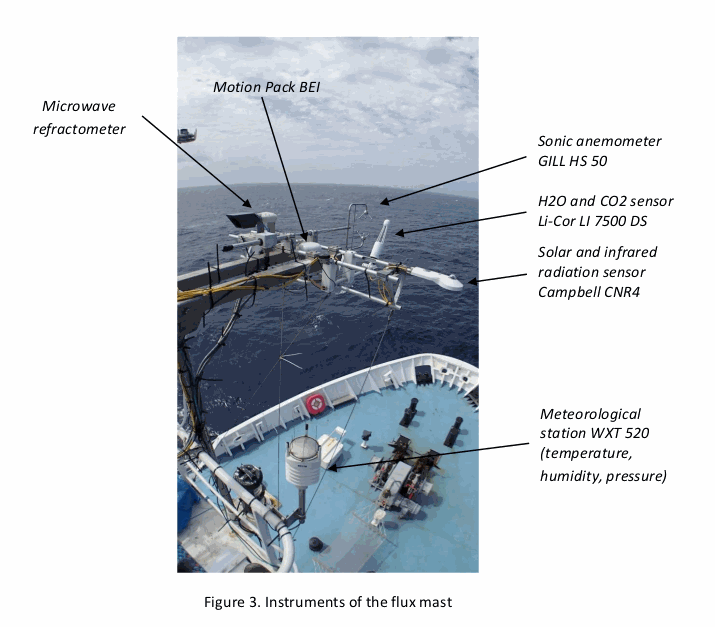
As part of the EUREC4A-OA project (H. Bellenger, S. Speich, LMD), which is the French oceanographic component of the larger EUREC4A field experiments, the “flux mast” national instrument was installed on the Reseach Vessel R/V Atalante from Genavir. The flux mast holds instruments that measure atmospheric turbulence and meteorological variables. The collected data are used to estimate the turbulent fluxes of momentum and heat at the air-sea interface. Specifically, the flux mast instruments measure air pressure, air temperature, humidity, air refraction index, H2O, the three components of the wind vector, and the upward and downward solar and infrared radiation fluxes. The fluxes calculated are the latent and sensible heat fluxes, and the friction velocity. DOI : https://www.seanoe.org/data/00661/77341/
-

Survey of water level of Azigza lake and meteorological data.
-

The dataset gives the variations of several climatic variables on the 0–10,000 year BP period by increment of 100 year. The variables are reconstructed using pollen data and an inverse vegetation model (BIOME4). The variables are expressed in term of anomalies according to their present reconstructions (0–100 years BP). The resolution of 100 years is certainly not reached for all the pollen diagrams used in the reconstruction. It is rather a maximum resolution. In reality, the time-series at that time step are rather smoothed and it should be unrealistic to interpret events with a length inferior to several centuries. Details are given in Guiot, J., Kaniewski, D., 2015. The Mediterranean Basin and Southern Europe in a warmer world: what can we learn from the past ? Frontiers in Earth Science, 3, 'http://dx.doi.org/10.3389/feart.2015.00028'.
-
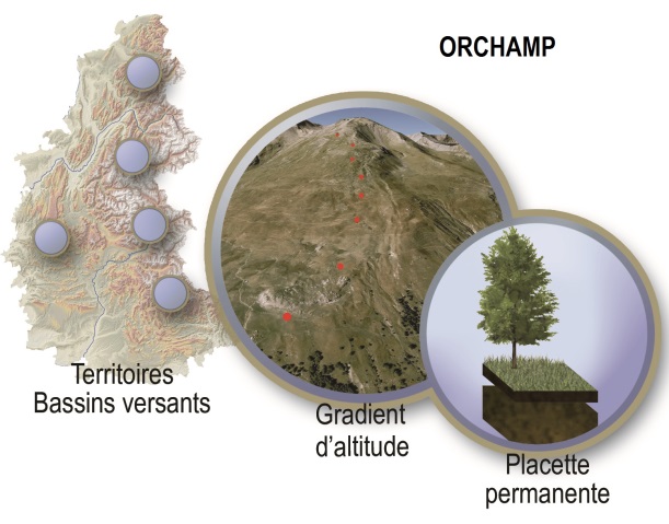
Le projet Orchamp s’inscrit dans le dispositif Sentinelles des Alpes, de la Zone Atelier Alpes. L’objectif est de saisir dans le temps et dans l’espace les dynamiques couplées entre le climat, l’utilisation des terres, la biodiversité de plusieurs groupes taxonomiques et le fonctionnement des écosystèmes de montagne, à l’échelle des Alpes françaises. Ce projet fédère une large communauté d’acteurs académiques et non-académiques autour d’un objectif commun : observer et prédire l’évolution de la biodiversité dans tout l’arc alpin en réponse aux forçages du climat et du changement d’usage des terres. ORCHAMP constitue un dispositif d’observation à échelles spatiales emboitées. Des protocoles simples et standardisés sont répétés sur des placettes permanentes et sur le temps long (> 20 ans). Ils permettent un suivi tous les 5 ans des écosystèmes : relevés botaniques et forestiers, analyses physico-chimiques et structure du sol, analyses de l’ADN environnemental du sol, télédétection, données météorologiques, pression anthropique et du pâturage. Cet observatoire pluridisciplinaire, privilégie une approche systémique de l’étude des territoires alpins, en entrecroisant les regards sur les trajectoires socio-économiques, les forçages macro et micro climatiques, les perturbations naturelles et les dynamiques des biodiversités. Enfin, à l’ère des données ouvertes (open data), l’ensemble des données récoltées et validées, sera structuré et diffusé afin de garantir sa réutilisation par tous, sans restriction aucune.
-

The MAP-IO (Marion Dusfresne Atmospheric Program - Indian Ocean) program aims to make up for the lack of observation in this region of the earth by equipping the Marion Dufresne vessel (https://taaf.fr/en/marion-dufresne-and-astrolabe/) with a set of in-situ instruments and remote sensing for the atmosphere and marine biology studies. This program has been labeled by the French Commission Nationale de la Flotte Hauturière (CNFH, https://www.flotteoceanographique.fr/) for the period 2021 to 2024. During this period, MAP-IO will operate as a scientific program for the acquisition and scientific enhancement of four years of data. This period will also serve as an operational prototype to study the feasibility of switching the program to a permanent observatory aimed at integration into international infrastructures networks such as ACTRIS (https://www.actris.eu/) or ICOS (https://www.icos-cp.eu/). - more informations on the project : http://www.mapio.re/ The Cytosense automated flow cytometer from the cytobuoy compagny was installed onboard the Marion Dufresnes Sea Water supply, to run semi continuously samples for phytoplankton functional groups resolution. Sample acquisition was schedulled once avery two hours. The data corresponds to abundances in cells/ml, mean forward scatter and red fluorescence in arbitrary units, per group. The groups are identified as standard groups following the BODC F02 vocabulary and the corresponding selections sets named following expert names.
-
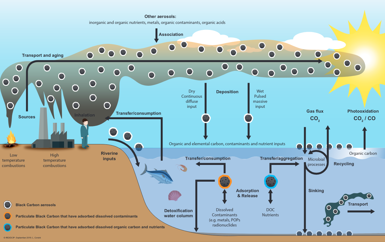
The scientific objectives of the project SOOT-SEA the objectives of this study in northern Vietnam are to determine: - (1) the composition of fine particles in order to assess their health, climatic and environmental impacts, - (2) their origin, both geographical and sectoral, - (3) atmospheric deposition fluxes, - (4) fluvial fluxes of black carbon towards the ocean. Study carried out during a complete annual cycle (weekly frequency). Aerosols were sampled for 24 hours using a large volume PM2.5 collector. Samples collected on quartz filters were analyzed to determine the concentrations of: - organic carbon (OC) and - elemental carbon (EC), - organic nitrogen (ON), - metals (Hg, Al, Ti, V, Cr, Mn, Fe, Co , Ni, Cu, Zn, As, Ag, Cd, Sn, Sb, Cs, Ce, Nd, Pb, U), - Pb isotopes, - PAHs, sugars, ions, organic acids, humic-like substances (HULIS). The oxidizing potential (OP) of these particles was determined using the DTT (Dithiotreithol) method. Citation: Mari, X., Uzu, G., Jaffrezo, J.-L., Dominutti, P., Chifflet, S., Tedetti, M., Guigue, C., Guyomarc’h , L., Heimburger, L.-E., & Raimbault, P. (2017). SOOT-SEA : Impact of Black Carbon in South East Asia [Data set]. MIO UMR 7294 CNRS. https://doi.org/10.34930/858FCE6B-A882-43C0-B5D0-81E80EFA7A1C
-
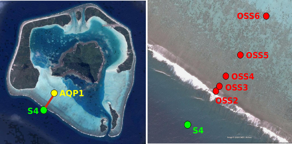
Maupiti ("the Stuck Twins'') is a diamond-shaped island located in the western part of the Society archipelago in French Polynesia. The present study focuses on the data recovered over a single cross-barrier transect located in the south-west barrier during the MAUPITI HOE field campaign, from 5 to 18 July 2018. The studied area is representative of the reef structure observed along the 4km-long southwestern barrier reef, showing an alongshore-uniform structure exposed to swell approaching with weak incident angles, a healthy reef colony. In the cross-barrier direction, the reef displays a clear partitioning of bottom roughness that ranges from low-crested compact structures at the reef crest to higher and sparser coral bommies on the backreef. The experimental setup was specifically designed to analyse and differentiate the dynamics over three roughness-contrasting sections found over the barrier reef. The scientific objectives of the project MAUPITI HOE are to understand the hydrodynamics of an archetypal reef-lagoon system of a high volcanic reef island. The physical functioning of the hydrosystem involves a fine coupling between water levels, waves (including wind, infragravity and VLF waves), currents and seabed structure (reef roughness). Four pressure sensors (OSS3, OSS4, OSS5, OSS6) have been deployed across the reef flat/ backreef, outside the surf zone. The bottom pressure is measured continuously at 10 Hz, and are converted into free surface elevation assuming hydrostaticity. An electrocurrent meter S4 provides the wave forcing while AQP1 is a velocity profiler providing the transports. The bed profile is obtained from the combination of (I) boat survey in the deeper part and (ii) high resolution GNSS RTK topography by feet. Two datasets are available: one is concerning the mean parameters linked to the reef barrier dynamics, and the second dataset is concerning the wave friction.
-
Maupiti ("the Stuck Twins'') is a diamond-shaped island located in the western part of the Society archipelago in French Polynesia. The present study focuses on the data recovered over a single cross-barrier transect located in the south-west barrier during the MAUPITI HOE field campaign, from 5 to 18 July 2018. The studied area is representative of the reef structure observed along the 4km-long southwestern barrier reef, showing an alongshore-uniform structure exposed to swell approaching with weak incident angles, a healthy reef colony. In the cross-barrier direction, the reef displays a clear partitioning of bottom roughness that ranges from low-crested compact structures at the reef crest to higher and sparser coral bommies on the backreef. The experimental setup was specifically designed to analyse and differentiate the dynamics over three roughness-contrasting sections found over the barrier reef. Four pressure sensors (OSS3, OSS4, OSS5, OSS6) have been deployed across the reef flat/ backreef, outside the surf zone. The bottom pressure is measured continuously at 10 Hz, and are converted into free surface elevation assuming hydrostaticity. An electrocurrent meter S4 provides the wave forcing while AQP1 is a velocity profiler providing the transports. The bed profile is obtained from the combination of (I) boat survey in the deeper part and (ii) high resolution GNSS RTK topography by feet. S4 position : -16.47109°N; -152.2782°E OSS3 position: -16.46968°N; -152.27698°E OSS4 position : -16.46931°N; -152.27676°E OSS5 position : -16.46851°N;-152.27614°E OSS6 position: -16.46706°N; -152.27504°E AQP1 position: -16.46318°N ; -152.27348°E
-
Sortie du modèle atmosphérique WRF et Meso-NH