 OSU Pytheas - Data Catalog
radar
Type of resources
Topics
INSPIRE themes
Keywords
Contact for the resource
Provided by
Formats
Representation types
Update frequencies
status
Scale
-

In the framework of the SNO/SOERE MOOSE (Mediterranean Ocean Observing System on Environment https://www.ir-ilico.fr/Les-reseaux-elementaires/Fiches-d-identite-des-reseaux-elementaires/MOOSE ) program, the Mediterranean Institute of Oceanography is operating coastal High Frequency Surface Wave Radars (HF radar) on the North Western Mediterranean coast. This activity is also supported by the following European Research Infrastructure Jerico-Next (https://www.jerico-ri.eu), and Intereg MED programs as Impact and Sicomar +. HF radar provide high resolution (3-5 km), synoptic view of surface currents from the shore up to 80 km off shore at hourly time scales. The measurement principle is based on the Doppler effect created by an additional current on the intrinsic speed of the waves selected by radar-sea interactions, called Bragg waves, having a wavelength of half that of the radar e.m. waves and propagating in the axis of observation (radial currents). A single radar scans the sea in azimuth and determines the radial components of the current at each adjacent cell along each azimuth. Two separate radars for the same area from different angles then collect the information necessary for mapping vector current from the combination of the two sets of radial components. The HF radar data set is made of monthly averaged surface currents, geo-referenced on cartesian lon/lat coordinates. The radial velocities maps are provided applying a Direction Finding technique (instead of traditional Beam Forming) not only to the full array of antenna but also to subarrays made of a smaller number of sequential antennas, a method which we refer to as "antenna grouping". Radials from Peyras-Peyras and Porquerolles-Benat are computed to reconstruct the vector field.
-
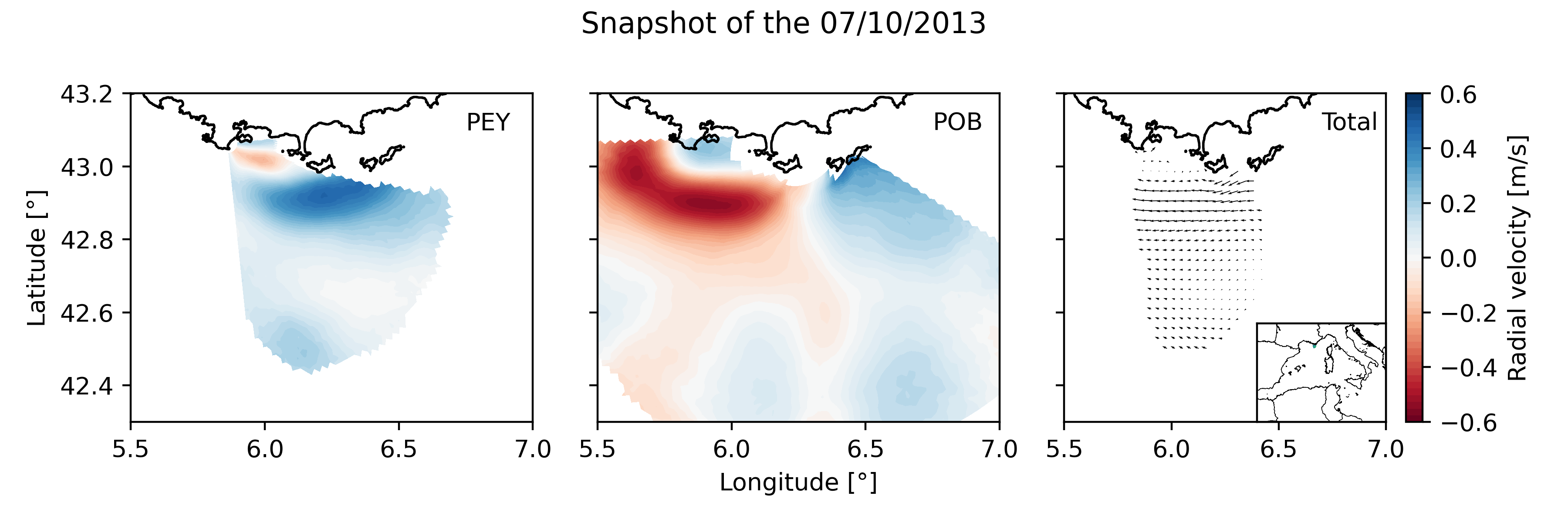
Daily High Frequency Radar (HFR) surface current data (radial velocity files and total velocity file) from 2 different stations located on the French Mediterranean coast (Toulon), spanning from January 2012 to December 2019. The radial datasets have been processed to remove outliers. Then, the gaps in the data have been filled using the DINEOF algorithm. The total velocity is then reconstructed from the filled radial velocity files, and projected onto a cartesian grid of 1km x 1km. The HFR data comes from two systems, one monostatic radar PEY (located at Fort Peyras, La Seyne sur mer), and one bistatic POB (emitter located at Cap Bénat - Bormes les Mimosas, and transmitter on Porquerolles Island). The HFR data is initially hourly sampled. To remove the outliers of the data, for each timestep, a Probability Density Function (PDF) is computed on the spatial gradient of each radial map. Pixels with a spatial gradient with a probability under 3% are removed. Additionnally, for each pixel, a PDF is computed on the temporal gradient of its whole timeseries. Timesteps with a temporal gradient that have a probability under 1% are then removed. Then we proceed to a preliminary temporal and spatial hole filling of the missing data. For the timeseries of each pixel, timesteps that are surrounded by valid values within 3 hours (i.e. 3 timesteps) are filled by a weighted linear interpolation. For each timestep, pixels of the map surrounded by values within 1 grid point are filled in the same way. The radial data is then daily averaged. The DINEOF algorithm (http://modb.oce.ulg.ac.be/mediawiki/index.php/DINEOF) is run in a multivariate way (2 radial velocity files) using 50 EOF modes for the reconstruction. At some timesteps (shown by the flag variable of the file), the filling has not been possible, and the missing maps have been replaced by the temporal average radial map. The filled radial velocities are then locally interpolated onto a cartesian grid of 1km spatial resolution using a Weighted Least Square method. HF radar sites : - Peyras : 43°03'47.4"N, 5°51'40.3"E - Porquerolles (transmitter only): 42°58'59.0"N, 6°12'15.3"E - Bénat (receiver only): 43°05'31.5"N, 6°21'26.5"E EUROPEAN DIRECTORY OF MARINE ENVIRONMENTAL RESEARCH PROJECTS (EDMERP) : - SICOMAR PLUS(12402), IMPACT(12271), MOOSE(11574), and JERICO NEXT(12227) EQUIPEMENTS: - High Frequency Surface Wave radar WERA from HELZEL MESSTECHNIK PARAMETERS: - sea surface current Citation: Molcard, A., & Bourg, N. (2021). HF RADAR - French Riviera (Mediterranean Institute of Oceanography) - daily surface currents filled with DINEOF [Data set]. MIO UMR 7294 CNRS. https://doi.org/10.34930/9263C4DF-4F55-4C5A-B183-C40EE1D844B1
-
Hourly High Frequency Radar (HFR) surface current data (ocean surface velocity) from 2 different stations located on the French Mediterranean coast (Toulon), processed in real time. The total velocity is then reconstructed from the filled radial velocity files, and projected onto a cartesian grid of 1km x 1km. The HFR data comes from two systems, one monostatic radar PEY (located at Fort Peyras, La Seyne sur mer), and one bistatic POB (receiver located at Cap Bénat - Bormes les Mimosas, and transmitter on Porquerolles Island). The HFR data is initially hourly sampled. The radial velocity are processed by an algorithm of Directional of Arrival Finding with a self-calibration method developed by our laboratory. HF radar sites : - Peyras : 43°03'47.4"N, 5°51'40.3"E - Porquerolles (transmitter only): 42°58'59.0"N, 6°12'15.3"E - Bénat (receiver only): 43°05'31.5"N, 6°21'26.5"E EUROPEAN DIRECTORY OF MARINE ENVIRONMENTAL RESEARCH PROJECTS (EDMERP) : - SICOMAR PLUS(12402), IMPACT(12271), MOOSE(11574), and JERICO NEXT(12227) EQUIPEMENTS: - High Frequency Surface Wave radar WERA from HELZEL MESSTECHNIK PARAMETERS: - sea surface current Citation: - Dylan Dumas, Charles-Antoine Guerin, Self-calibration and antenna grouping for bistatic oceanographic High-Frequency Radars,2020, https://arxiv.org/abs/2005.10528