 OSU Pytheas - Data Catalog
chlorophyll
Type of resources
Topics
INSPIRE themes
Keywords
Contact for the resource
Provided by
Formats
Representation types
Update frequencies
status
Scale
-
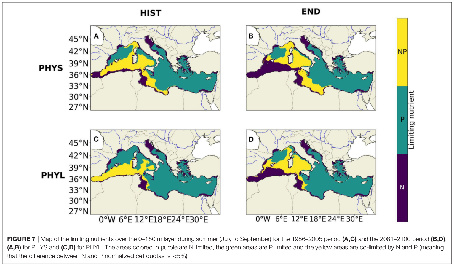
"Towards an integrated prediction of Land & Sea Responses to global change in the Mediterranean Basin" The LaSeR-Med project aims at investigating the effects of climate change and of mediterranean population growth on some major indicators of the Mediterranean Sea (primary production, carbon export, zooplankton biomass available for small pelagic fishes, pH, dissolved oxygen) using and integrated model encompassing a socio-economic model, a continental model of agro-ecosystems, and a physical ocean-atmosphere model coupled to a biogeochemical model of the ocean. Last, a model for the widespread species of jellyfish Pelagia Noctiluca (Berline et al., 2013) uses biogeochemical outputs as food forcing for the jellyfish. In this project, our aim was first to investigate the large-scale and long-term impacts of variations in river inputs on the biogeochemistry of the Mediterranean Sea over the last decades (see Pages et al., 2020a). In the second phase, a climate scenario (RCP8.5) alone (Pages et al., 2020b) or combined with a “land-use” scenario derived to ensure the same level of food availability as today in 2050 have been run to investigate its effect on these indicators and to analyze the observed changes on the structure and the functioning of planktonic food web. This interdisciplinary project provided the framework for joint discussions on each of the sub-models that constitute the integrated model, namely the socio-economic model (Ami et al., in prep., Mardesic et al., in prep.) created ex nihilo by researchers from AMSE, INRA and GREQAM, the continental agro-ecosystem model LPJmL (Bondeau et al., 2007) worked on at IMBE so as to include the nitrogen and phosphorous cycles in the frame of the present project, and the ocean biogeochemical model Eco3M-Med developed at MIO (Baklouti et al., 2006; Alekseenko et al. 2014, Guyennon et al., 2015; Pagès et al., 2020a), forced by ocean physics, either using the ocean model NEMO-Med12 forced by atmosphere at IPSL (simulation NM12-FREE run with the NEMO-MED12 model and used for our hindcast simulation, see below) or a coupled ocean-atmosphere model at CNRM (physical forcing provided by CNRM-RCSM4, see below). Details on the CNRM-RCSM4 model The CNRM-RCSM4 simulates the main components of the Mediterranean regional climate system and their interactions. It includes four different components: (i) The atmospheric regional model ALADIN-Climate (Radu et al., 2008; Colin et al., 2010; Herrmann et al., 2011) characterized by a 50 km horizontal resolution, 31 vertical levels, and a time step of 1800 s, (ii) the ISBA (Interaction between Soil Biosphere and Atmosphere) land-surface model (Noilhan and Mahfouf, 1996) at a 50 km horizontal resolution, (iii) the TRIP (Total Runoff Integrating Pathways) river routing model (Oki and Sud, 1998), used to convert the runoff simulated by ISBA into rivers (Decharme et al., 2010; Szczypta et al., 2012; Voldoire et al., 2013), and (iv) the Ocean general circulation model NEMO (Nucleus for European Modeling of the Ocean, Madec and NEMO-Team, 2016) in its NEMO-MED8 regional configuration (Beuvier et al., 2010). NEMO-MED8 is characterized by a horizontal resolution of 1/8° (grid cells size from 6 to 12 km), a vertical resolution of 43 vertical levels (cell height ranging from 6 to 200 m), and a time step of 1200 s. More details about the CNRM-RCSM4 model can be found in Sevault et al. (2014). Keywords: - Mediterranean Sea, river inputs, chlorophyll, nutrients, phytoplankton, bacteria, zooplankton, dissolved and particulate organic detrital matter Citation: Pagès, R., Baklouti, M., Barrier, N., Richon, C., Dutay, J.-C., and Moutin, T. (2020a). Changes in rivers inputs during the last decades significantly impacted the biogeochemistry of the eastern Mediterranean basin: a modelling study. Prog. Oceanogr. 181:102242. doi:10.1016/j.pocean.2019.102242 Pagès, R., Baklouti, M., Barrier, N., Ayache, M., Sevault, F., Somot, S. and Moutin, T. (2020b). Projected Effects of Climate-Induced Changes in Hydrodynamics on the Biogeochemistry of the Mediterranean Sea Under the RCP 8.5 Regional Climate Scenario. Front. Mar. Sci. 7:563615. doi:10.3389/fmars.2020.563615 Ayache, M., Bondeau, A., Pagès, R., Barrier, N., Ostberg, S. and Baklouti, M. (2020). LPJmL-Med – Modelling the dynamics of the land-sea nutrient transfer over the Mediterranean region–version 1: Model description and evaluation. Geoscientific Model Development Discussions, Copernicus Publ.
-
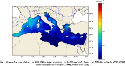
"Towards an integrated prediction of Land & Sea Responses to global change in the Mediterranean Basin" The LaSeR-Med project aims at investigating the effects of climate change and of mediterranean population growth on some major indicators of the Mediterranean Sea (primary production, carbon export, zooplankton biomass available for small pelagic fishes, pH, dissolved oxygen) using and integrated model encompassing a socio-economic model, a continental model of agro-ecosystems, and a physical ocean-atmosphere model coupled to a biogeochemical model of the ocean. Last, a model for the widespread species of jellyfish Pelagia Noctiluca (Berline et al., 2013) uses biogeochemical outputs as food forcing for the jellyfish. In this project, our first aim was to investigate the large-scale and long-term impacts of variations in river inputs on the biogeochemistry of the Mediterranean Sea over the last decades (see Pages et al., 2020a). This interdisciplinary project provided the framework for joint discussions on each of the sub-models that constitute the integrated model, namely the socio-economic model (Ami et al., in prep., Mardesic et al., in prep.) created ex nihilo by researchers from AMSE, INRA and GREQAM, the continental agro-ecosystem model LPJmL (Bondeau et al., 2007) worked on at IMBE so as to include the nitrogen and phosphorous cycles in the frame of the present project, and the ocean biogeochemical model Eco3M-Med developed at MIO (Baklouti et al., 2006; Alekseenko et al. 2014, Guyennon et al., 2015; Pagès et al., 2020a), forced by ocean physics, either using the ocean model NEMO-Med12 forced by atmosphere at IPSL (simulation NM12-FREE run with the NEMO-MED12 model and used for our hindcast simulation, see below) or a coupled ocean-atmosphere model at CNRM (physical forcing provided by CNRM-RCSM4, see below). Details on simulation NM12-free: The historical simulation used in this work is referred to as the NM12-FREE (no reanalysis no data assimilation) which started in October 1979 and ended in June 2013 (Hamon et al., 2016). It has been run with the general circulation model NEMO in its regional configuration NEMO-MED12 based on a horizontal resolution of 1/12 de degree (6.5 to 8 km cells) and a 75-level vertical resolution (of 1 m width at the surface to 135 m at the seabed). For this simulation, runoff and river inputs in the NM12 domain came from the inter-annual data of Ludwig et al. (2009) and the atmospheric forcing was based on the dynamical downscaling of the ERA-INTERIM reanalysis, i.e. ALDERA which has a 12 km spatial resolution and a 3 h temporal resolution. More details on the NM12-FREE simulation are given in Hamon et al. (2016). Keywords: - Mediterranean Sea, river inputs, chlorophyll, nutrients, phytoplankton, bacteria, zooplankton, dissolved and particulate organic detrital matter Citation: Pagès, R., Baklouti, M., Barrier, N., Richon, C., Dutay, J.-C., and Moutin, T. (2020a). Changes in rivers inputs during the last decades significantly impacted the biogeochemistry of the eastern Mediterranean basin: a modelling study. Prog. Oceanogr. 181:102242. doi:10.1016/j.pocean.2019.102242 Ayache, M., Bondeau, A., Pagès, R., Barrier, N., Ostberg, S. and Baklouti, M. (2020). LPJmL-Med – Modelling the dynamics of the land-sea nutrient transfer over the Mediterranean region–version 1: Model description and evaluation. Geoscientific Model Development Discussions, Copernicus Publ.
-
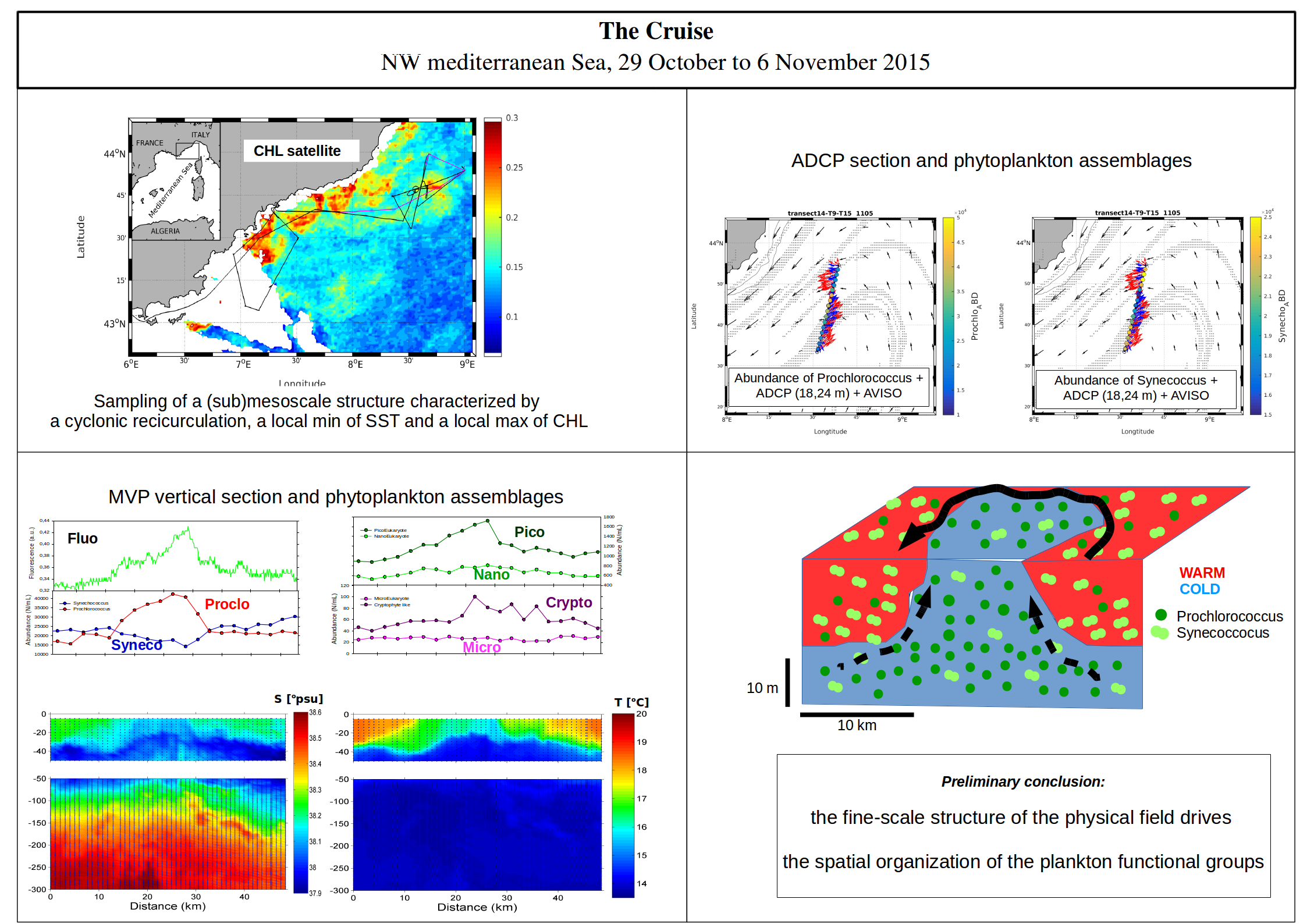
Observing physical-biological coupling at the submesoscale thanks to innovative methodologies for sampling in situ at high resolution. The scientific objectives of the project OSCAHR (Observing Submesoscale Coupling At High Resolution) are to characterize a submesoscale structure and to study its influence on the distribution of biogenic elements and the structure and dynamics of the first trophic levels associated with it. The strategy is based on an adaptive satellite-based approach and on the use of very recent or new instruments allowing to sample the surface layer at high spatial and temporal frequency. The original set of multidisciplinary data will allow to validate measurements from remote sensing (radar altimetry, ocean color, reconstitution of planktonic assemblages) in coastal areas. ----- Les objectifs scientifiques du projet OSCAHR (Observing Submescale Coupling At High Resolution) sont de caractériser une structure dynamique de sous-mesoéchelle et d'étudier son influence sur la distribution des éléments biogènes et sur la structure et la dynamique des premiers niveaux trophiques qui lui sont associés. Notre méthodologie comprend l'utilisation de nouvelles plateformes d'observation pour l'échantillonnage de la couche superficielle de l'océan à une fréquence spatiale et temporelle élevée. En particulier, un MVP (Moving Vessel Profiler) est déployé avec des capteurs CTD, Fluorescence et LOPC (Laser Optical Particle Counter) et une nouvelle version du cytomètre automatisé en flux est installée pour l'échantillonnage en temps réel et à haut débit des groupes fonctionnels phytoplanctoniques, du microphytoplancton aux tocyanobactéries (dont le Prochlorococcus). Deux sources d'eau de mer ont été utilisées dans l'OSCAHR : en plus de la prise d'eau de surface à bord, un nouveau système de pompage est développé et testé afin d'échantillonner la colonne d'eau supérieure à une résolution d'un mètre.
-
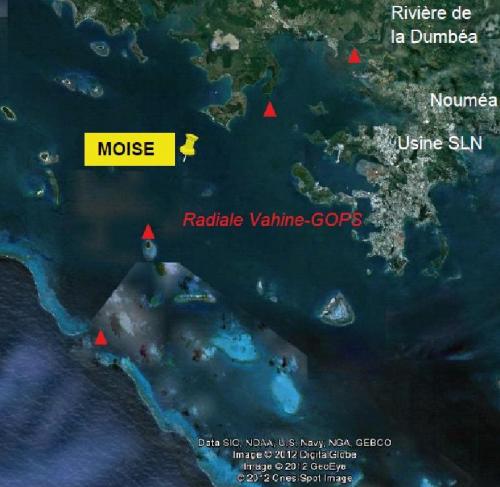
The MOISE project is part of a medium- and long-term approach to monitoring the coastal environment in New Caledonia. Initiated at the end of 2011, this monitoring is based on the installation of a fixed mooring with automatic physico-chemical, optical and biological measurement systems. This approach makes it possible to address the different scales of temporal variability characteristic of the dynamics and functioning of the lagoon ecosystem, including the daily scale. Since 2012, this high-frequency in situ monitoring has been supplemented by monthly monitoring with discrete measurements and vertical profiles over the entire water column; the parameters measured and the methods used are modelled on those of the SOMLIT network, with a view to MOISE's accreditation as an observation station. Medium and long term observation of the coastal environment in New Caledonia. Climatic variability in tropical zones. Evolution of the monthly, seasonal and interannual variability of the hydrological and biogeochemical characteristics of marine waters at a point located off the Bay of Dumbéa (N-NW of Noumea, New Caledonia) on a depth of 10m. Measurement of the impact of natural and anthropogenic forcings on the environment, study/quantification of the consequences of this variability, both natural and anthropogenic, on the structuring and functioning of the pelagic ecosystem, and in particular on the appearance of diazotrophic blooms. Validation of the images obtained by different ocean color sensors by monitoring the variations of the "water color" for an adjustment of the algorithms of calculation of the chlorophyll obtained from satellite reflectance. Possible measurements of the impact of the atmospheric plume of the SLN (Société Le Nickel = nickel treatment by pyrometallurgy) following preliminary work.