 OSU Pytheas - Data Catalog
5000
Type of resources
Available actions
Topics
INSPIRE themes
Keywords
Contact for the resource
Provided by
Years
Formats
Representation types
Update frequencies
status
Scale
-
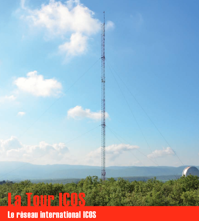
Une infrastructure de recherche européenne de mesure des concentrations atmosphériques des gaz à effet de serre et des flux de carbone sur les écosystèmes et l’océan. La tour ICOS (pour Integrated Carbon Observation System) installée à l'Observatoire de Haute Provence (OHP), haute de 100 m est une antenne régionale du dispositif permettant d’étudier la place de la forêt méditerranéenne dans le bilan de carbone. Elle est équipée d’instruments à trois niveaux (10, 50, 100 m). Le réseau est doté de 3 types de stations réparties sur le territoire : continentales, côtières et de montagne. Chacune de ces stations mesure les paramètres suivants : * température, direction et vitesse du vent, pression atmosphérique, humidité * CO2, CH4, CO, H2O * hauteur de couche limite atmosphérique (lidar) Les objectifs scientifiques de ce programme européen sont de : * tracer les flux de carbone en Europe et dans les régions adjacentes par observation des écosystèmes, de l'atmosphère et des océans à travers des réseaux intégrés, * fournir les observations à long terme nécessaires pour comprendre l'état présent et prévoir le comportement du carbone global et des émissions des gaz à effet de serre, * surveiller et évaluer l'efficacité de la séquestration du carbone et/ou de la réduction des émissions de gaz à effet de serre sur la composition globale de l'atmosphère, en prenant en compte les sources et les puits par région géographique et par secteur d'activité. L'infrastructure ICOS permet d'accueillir des chercheurs pour des campagnes de recherches
-
Communities of Rhopalocera (Lepidoptera) butterflies in 24 urban parks in Marseille Sampling of Rhopalocera communities: 7 to 12 transects in each of 24 urban parks in Marseille every 2 years since 2008. Increasing numbers of cities are currently developing sustainable policies aimed at promoting urban biodiversity and ecological dynamics through the planning of green networks and the implementation of more sustainable management practices. These human activities can strongly influence environmental factors on which the organization of ecological communities at different scales depends. Thus, it is of fundamental importance to understand the relative impact of local management, green space design and landscape features on the distribution and the abundance of species in urban areas. On the basis of 2 years of butterfly surveys in urban public parks within an extensive Mediterranean metropolitan area, Marseille (South-East France), the aim of this paper is to provide a better understanding of the effect of these three environmental scales (plot, park, landscape) on the composition and organization of species assemblages. Using variation partitioning and nestedness analysis on ecological data aggregated at plot-level and park-level respectively, we demonstrate the preponderant effect of landscape scale features on urban butterfly assemblages. Our results also highlight an important co-variation of plot management, park layout and urban landscape features, in their interaction with the community structure of urban butterflies. Although there is no significant species-area relationship, significantly nested patterns arise in species composition. Selective colonization appears as a driving force constraining the constitution of species assemblages within the city. However, a prospective study on adjacent more natural areas suggests that biotic limitations, interspecific competition and habitat filtering may play an important role if a larger portion of the urbanization gradient is explored, which remains to be investigated.
-

Suivi longitudinal sur 9 sites de terrain au Sénégal de l’observatoire ObsMiCE Paramètres mesurés: - détermination spécifique ; - indices d’abondance ; - données morphométriques, - estimation de l’âge, - paramètres de reproduction indicateurs de la dynamique des populations animales ; - prélèvements de tissus, d’ectoparasites et d’endoparasites ; - données environnementales ; - prévalence de parasites et pathogènes
-

The Health and Demographic Surveillance System (HDSS) in Niakhar, a rural area of Senegal, is located 135 km east of Dakar. This HDSS has been set up in 1962 by the Institut de Recherche pour le Développement (IRD) to face the shortcomings of the civil registration system and provide demographic indicators. Some 65 villages were followed annually in the Niakhar area from 1962 to 1969. The study zone was reduced to eight villages from 1969 to 1983, and from then on the HDSS was extended to include 22 other villages, covering a total of 30 villages for a population estimated at 45,000 in December 2013. Thus 8 villages have been under demographic surveillance for almost 50 years and 30 villages for 30years. Vital events, migrations, marital changes, pregnancies, immunization are routinely recorded (every four months). The database also includes epidemiological, economic and environmental information coming from specific surveys. Data were collected through annual rounds from 1962 to 1987; rounds became weekly from 1987 to 1997; routine visits were conducted every three months between 1997and 2007 and every four months since then. The current objectives are 1) to obtain a long-term assessment of demographic and socio-economic indicators necessary for bio-medical and social sciences research, 2) to keep up epidemiological and environmental monitoring, 3) to provide a research platform for clinical and interdisciplinary research (medical, social and environmental sciences). Research projects during the last 5 years are listed in Table 2. The Niakhar HDSS has institutional affiliation with the Institut de Recherche pour le Développement (IRD, formerly ORSTOM). * Niakhar HDSS INDEPTH Core Dataset 1984-2016 (Release 2018). Provided by the INDEPTH Network Data Repository. http://indepth-ishare.org/index.php/catalog/132 * DOI : 10.7796/INDEPTH.SN013.CMD2016.v1 * https://doi.org/10.7796/INDEPTH.SN013.CMD2016.v1
-
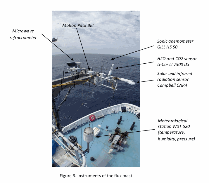
As part of the EUREC4A-OA project (H. Bellenger, S. Speich, LMD), which is the French oceanographic component of the larger EUREC4A field experiments, the “flux mast” national instrument was installed on the Reseach Vessel R/V Atalante from Genavir. The flux mast holds instruments that measure atmospheric turbulence and meteorological variables. The collected data are used to estimate the turbulent fluxes of momentum and heat at the air-sea interface. Specifically, the flux mast instruments measure air pressure, air temperature, humidity, air refraction index, H2O, the three components of the wind vector, and the upward and downward solar and infrared radiation fluxes. The fluxes calculated are the latent and sensible heat fluxes, and the friction velocity. DOI : https://www.seanoe.org/data/00661/77341/
-

In the framework of the SNO/SOERE MOOSE (Mediterranean Ocean Observing System on Environment https://www.ir-ilico.fr/Les-reseaux-elementaires/Fiches-d-identite-des-reseaux-elementaires/MOOSE ) program, the Mediterranean Institute of Oceanography is operating coastal High Frequency Surface Wave Radars (HF radar) on the North Western Mediterranean coast. This activity is also supported by the following European Research Infrastructure Jerico-Next (https://www.jerico-ri.eu), and Intereg MED programs as Impact and Sicomar +. HF radar provide high resolution (3-5 km), synoptic view of surface currents from the shore up to 80 km off shore at hourly time scales. The measurement principle is based on the Doppler effect created by an additional current on the intrinsic speed of the waves selected by radar-sea interactions, called Bragg waves, having a wavelength of half that of the radar e.m. waves and propagating in the axis of observation (radial currents). A single radar scans the sea in azimuth and determines the radial components of the current at each adjacent cell along each azimuth. Two separate radars for the same area from different angles then collect the information necessary for mapping vector current from the combination of the two sets of radial components. The HF radar data set is made of monthly averaged surface currents, geo-referenced on cartesian lon/lat coordinates. The radial velocities maps are provided applying a Direction Finding technique (instead of traditional Beam Forming) not only to the full array of antenna but also to subarrays made of a smaller number of sequential antennas, a method which we refer to as "antenna grouping". Radials from Peyras-Peyras and Porquerolles-Benat are computed to reconstruct the vector field.
-
L’île de Bagaud, réserve intégrale du Parc National de Port Cros (PNPC), fait actuellement l‘objet d’un programme décennal de restauration écologique en vue de la préservation de son patrimoine naturel. Cette restauration consiste à contrôler deux espèces exotiques envahissantes : le rat noir (Rattus rattus) et la griffe de sorcière (Carpobrotus sp.). Débuté en 2010, ce programme permet l’étude de plusieurs groupes taxonomiques avant (2010-2011) et après contrôle (2013-2019) : (1) la flore, (2) les arthropodes épigés et les insectes volants, (3) les squamates, (4) les oiseaux terrestres nicheurs et (5) les oiseaux marins nicheurs. Ce projet fédère une large communauté d’acteurs académiques et non-académiques autour d’un objectif commun : contrôler et si possible éradiquer les espèces invasives de la réserve intégrale et suivre la résilience des groupes taxonomiques cités ci-dessus. Partenaires pour le suivi et l’analyse des données : IMBE, PNPC, CBNMed, association Reptil’Var, association DREAM et LPO. Autres partenaires : PIM, INRA, Conservatoire du Littoral, Domaine du Rayol, Naturoscope, UE, Natura2000, TLV, Région Sud, Naturalia Consultants en Environnement.
-
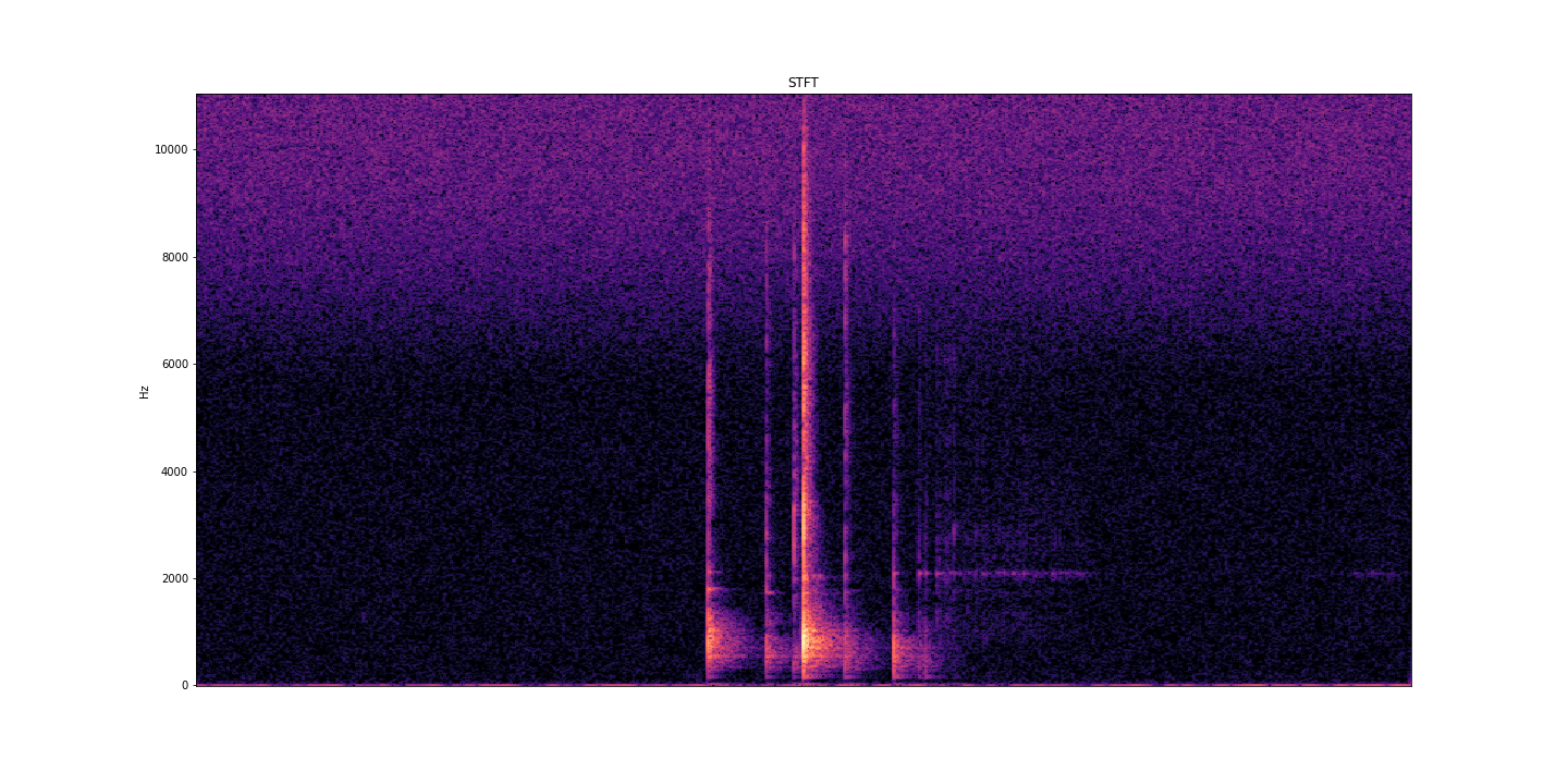
AcoustRivNN proposes to develop a system to estimate the flow and the granulometry of the sediment transport in a river from the acoustic pressure generated by the latter using methods from artificial intelligence. The estimation of the sediment flow carried by water, in rivers or estuaries, is a crucial issue for the management of the latter, allowing to carry out scientific studies, restoration or prevention projects, as well as operational works. Given the lack of effective methods to estimate the flow of sediment, the AcoustRivNN project proposes to provide a "proof of concept" by developing an original system based on deep learning to estimate the flow of coarse sediments from the simple acoustic pressure generated by the latter and measured by hydrophones. The originality of this project lies, in particular, in its interdisciplinary aspect proposing to adapt methods from artificial intelligence particularly effective in many applied fields. This project, which is part of the transversal axis 2: "Observations/information systems/modeling" of the ECCOREV federation, is structured in two phases: - Phase I proposes to build an acoustic database referenced in the laboratory necessary for the training of a neural network. - Phase II aims to develop a neural network model to characterize the acoustics of sediment flow. DOI: https://doi.org/10.34930/dc3225de-ef03-4134-927e-2347d75d8b41 Citation: Gassier, G., Michal, T., & Dussouillez, P. (2022). AcoustRivNN : flow and the granulometry of the sediment transport in a river from acoustic pressure [Data set]. CEREGE UMR 7330 CNRS. https://doi.org/10.34930/DC3225DE-EF03-4134-927E-2347D75D8B41
-
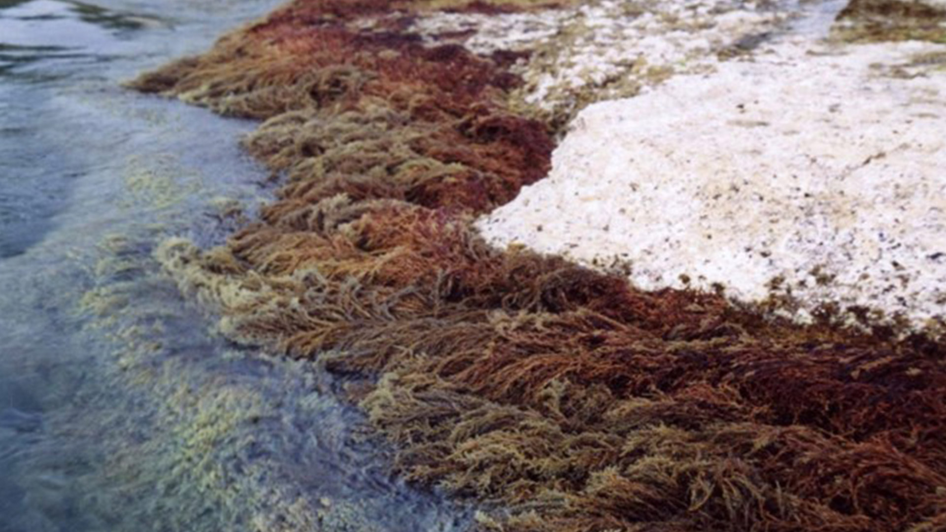
CARLIT : Évaluation de l’état écologique du littoral rocheux méditerranéen français – Descripteur ‘Macroalgue’ de la Directive Européenne Cadre sur l’Eau Dans le cadre du contrôle de surveillance DCE-Bassin Rhône côtier Méditerranée, la mise en œuvre du descripteur ‘Macroalgue’ a été mise en place depuis le printemps 2007 en utilisant la méthode CARLIT. Les communautés rocheuses des étages médio- et infralittoraux (frange supérieur de l’étage infralittoral souvent émergée), la géomorphologie et la nature de la roche ont été cartographiées à l’échelle 1/2 500ème. Un niveau de sensibilité écologique face aux perturbations sur une échelle de 1 (peu sensible) à 20 (très sensible) est attribué à chaque communauté. Les communautés ayant les niveaux de sensibilité les plus forts représentent les communautés climax de la zone littorale. Par une analyse géo-référencée, un indice de qualité environnementale est calculé, et permet ainsi de déterminer, pour chaque masse d’eau, un statut écologique établi suivant les critères de la Directive Cadre Européenne sur l’Eau. Les littoraux sédimentaires sont ignorés à l’exception des baies naturelles très fermées où les phanérogames peuvent être abondantes, ainsi que l’intérieur des ports et des marinas. Ces deux dernières zones étant trop perturbées, elles nécessitent l’utilisation d’autres indices comme par exemple l’analyse de l’eau. L’intégralité des côtes rocheuses françaises méditerranéennes a été cartographie (depuis 2007). La méthode CARLIT (CARtographie LITtorale) développée par Ballesteros et al., 2007 et modifié par Blanfuné et al., 2017, consiste à mesurer l'abondance et la distribution des communautés ou espèces de macroalgues dominantes présentes sur les substrats rocheux de l’étage médiolittoral et de l'horizon supérieur de l’étage infralittoral (0-50 cm de profondeur) en fonction de la géomorphologie de la côte (présence de falaise supérieure à 15 m de hauteur) et de la nature du substrat (naturel, artificiel, etc.). L'abondance des communautés est cartographiée à partir d’une petite embarcation longeant la côte au plus près du littoral et à 4-5 km/h. La méthode ne s’applique donc pas à des masses d’eau dont la côte est sableuse, où le descripteur macroalgues n’est pas pertinent. Par une analyse géoréférencée, un indice de qualité environnementale (EQR) est calculé, et permet ainsi de déterminer, pour chaque masse d’eau, un statut écologique (ES) établi suivant les critères de la Directive Cadre Européenne sur l’Eau. Une deuxième vague d’évaluation a commencé depuis 2012.
-
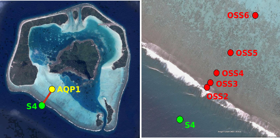
Maupiti ("the Stuck Twins'') is a diamond-shaped island located in the western part of the Society archipelago in French Polynesia. The present study focuses on the data recovered over a single cross-barrier transect located in the south-west barrier during the MAUPITI HOE field campaign, from 5 to 18 July 2018. The studied area is representative of the reef structure observed along the 4km-long southwestern barrier reef, showing an alongshore-uniform structure exposed to swell approaching with weak incident angles, a healthy reef colony. In the cross-barrier direction, the reef displays a clear partitioning of bottom roughness that ranges from low-crested compact structures at the reef crest to higher and sparser coral bommies on the backreef. The experimental setup was specifically designed to analyse and differentiate the dynamics over three roughness-contrasting sections found over the barrier reef. The scientific objectives of the project MAUPITI HOE are to understand the hydrodynamics of an archetypal reef-lagoon system of a high volcanic reef island. The physical functioning of the hydrosystem involves a fine coupling between water levels, waves (including wind, infragravity and VLF waves), currents and seabed structure (reef roughness). Four pressure sensors (OSS3, OSS4, OSS5, OSS6) have been deployed across the reef flat/ backreef, outside the surf zone. The bottom pressure is measured continuously at 10 Hz, and are converted into free surface elevation assuming hydrostaticity. An electrocurrent meter S4 provides the wave forcing while AQP1 is a velocity profiler providing the transports. The bed profile is obtained from the combination of (I) boat survey in the deeper part and (ii) high resolution GNSS RTK topography by feet. Two datasets are available: one is concerning the mean parameters linked to the reef barrier dynamics, and the second dataset is concerning the wave friction.