 OSU Pytheas - Data Catalog
TOSCA - Tracking Oil Spills & Coastal Awareness network
Couplage des données issues des Radar HF et des flotteurs pour améliorer la prévision des dérives des nappes pétrolières et les secours en mer.
Le projet TOSCA consiste à développer un réseau côtier de surveillance continue et de prévisions basé sur des radars HF et des instruments et modèles de dérive de nouvelle génération, visant à optimiser la réponse des autorités locales aux accidents de mer, en mettant un accent particulier sur la pollution par les déversements d'hydrocarbures et la recherche. et opérations de sauvetage (SAR).
Le projet TOSCA (réseau de surveillance des déversements d’hydrocarbures et des zones côtières) est cofinancé par le Fonds européen de développement régional dans le cadre du programme MED. Il vise à améliorer la qualité et l'efficacité du processus décisionnel en cas d'accident maritime concernant la pollution par les déversements d'hydrocarbures et les opérations de recherche et de sauvetage (SAR) en Méditerranée. Cela se fera avec l'aide d'un réseau comprenant les autorités locales, les décideurs politiques et des scientifiques, dotés d'un système de surveillance et de prévisions maritimes scientifiques et de la mise en œuvre d'outils d'aide à la décision et de plans d'action.
TOSCA project consists in the development of a coastal continuous monitoring & forecasting network based on HF radars & new generation drifting instruments & models, aimed at optimizing the response of local authorities to marine accidents, with a special emphasis on oil spill pollution & on search-and rescue (SAR) operations.
The TOSCA (Tracking Oil Spills & Coastal Awareness network) project is cofinanced by the European Regional Development Fund in the framework of the MED Programme. It intends to improve the quality and effectiveness of decision-making process in case of marine accidents concerning oil spill pollution and search and rescue (SAR) operations in the Mediterranean.This will be done with the help of a network including local authorities, policy makers and scientists, with a scientific maritime monitoring and forecasting system and with the implementation of decision support tools and action plans.
Simple
- Date (Publication)
- 2013-10-01
- Edition
- Citation identifier
- http://dataset.osupytheas.fr/geonetwork/srv/resources7d538d6b-dd15-42af-9de7-c9eac27a840d
- Purpose
-
The TOSCA (Tracking Oil Spills & Coastal Awareness network) project is cofinanced by the European Regional Development Fund in the framework of the MED Programme. It intends to improve the quality and effectiveness of decision-making process in case of marine accidents concerning oil spill pollution and search and rescue (SAR) operations in the Mediterranean.This will be done with the help of a network including local authorities, policy makers and scientists, with a scientific maritime monitoring and forecasting system and with the implementation of decision support tools and action plans.
- Status
- Completed
- Maintenance and update frequency
- As needed
-
Continents, countries, sea regions of the world.
-
-
Mediterranean Sea
-
-
GEMET - INSPIRE themes, version 1.0
-
-
Oceanographic geographical features
-
Sea regions
-
-
GEMET - Concepts, version 2.4
-
-
environmental data
-
ocean temperature
-
Mediterranean Sea
-
- Theme
-
-
Rescue, secours
-
Pollution
-
- Keywords
-
- Access constraints
- Copyright
- Use constraints
- otherRestictions
- Spatial representation type
- Vector
- Denominator
- 25000
- Language
- English
- Character set
- UTF8
- Topic category
-
- Oceans
- Description
-
Mediterranean Sea
))
- Begin date
- 2011-11-30
- End date
- 2013-12-31
- Supplemental Information
-
You can customize the template to suit your needs.
You can add
and remove fields and fill out default information (e.g. contact
details).
Fields you can not change in the default view may be accessible in the
more
comprehensive (and more complex) advanced view. You can even use the
XML editor
to create custom structures, but they have to be validated by the
system, so
know what you do :-)
- Reference system identifier
- WGS 1984
- Distribution format
-
-
NetCDF Files
(
1.0
)
-
NetCDF Files
(
1.0
)
- OnLine resource
-
site web officiel TOSCA
(
WWW:LINK-1.0-http--link
)
TOSCA project consists in the development of a coastal continuous monitoring & forecasting network based on HF radars & new generation drifting instruments & models, aimed at optimizing the response of local authorities to marine accidents, with a special emphasis on oil spill pollution & on search-and rescue (SAR) operations.
- OnLine resource
-
TOSCA data download
(
WWW:LINK-1.0-http--link
)
Campagnes de Mesures du projets TOSCA
- Hierarchy level
- Dataset
- Statement
-
Données issues des campagnes de mesure du projet TOSCA
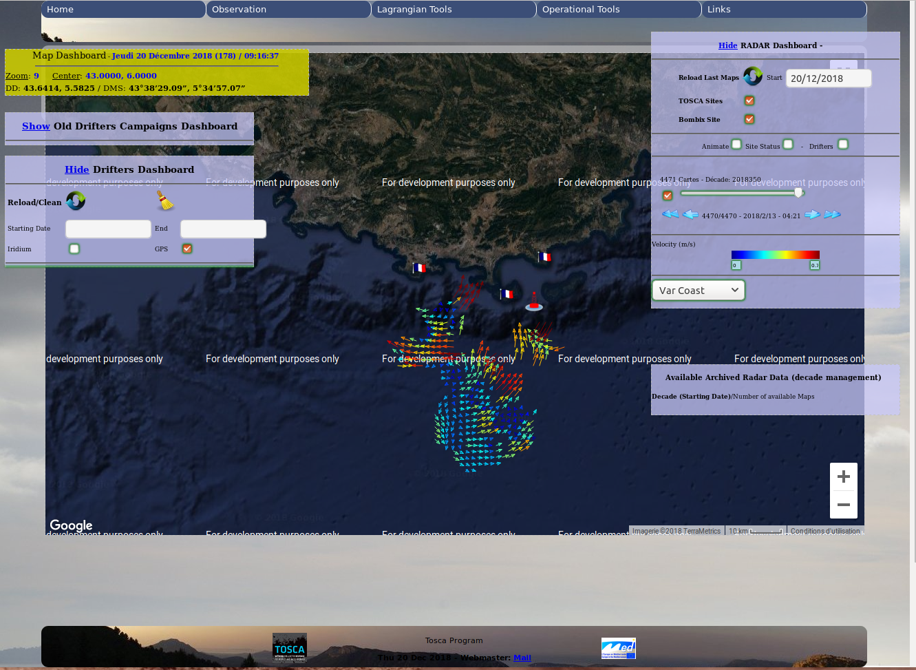
Surface currents can be measured efficiently from the drifts of Lagrangian instruments tracked by, and transmitting data to, satellite systems (Iridium). These surface drifting buoys (called drifters) are low-cost, expandable systems that measure sea surface temperature (SST and currents through their displacements between satellite fixes. Drifters are actually quasi-Lagrangian since they do not perfectly follow the surface water because of the effects of the winds and waves acting on them. However, over the past two decades, drifters, such as the CODE and SVP designs, have been developed to reduce these effects.
This TOSCA tool has been designed to decode and display information sent by drifters in a near real time way. It permit also to display past Intensive Observation Period done during the TOSCA project. It has been used during TOSCA campaigns to follow drifters at sea.
This tool will allow you to display GPS and/or IRRIDIUM positions (using radio buttons) and choosing the displaying period (using calendar Input fileds).
- File identifier
- 44ad1661-42b8-4966-bf80-28624943dbfd XML
- Metadata language
- English
- Character set
- UTF8
- Hierarchy level
- Dataset
- Hierarchy level name
-
dataset
- Date stamp
- 2020-02-10T10:47:53
- Metadata standard name
-
ISO 19115:2003/19139
- Metadata standard version
-
1.0
Overviews
Spatial extent
Provided by
